Fourteen Years Ago, December 26, 2004: Indonesia’s Indian Ocean 9.0 Tsunami. Why Did the Information Not Get Out?


UPDATE
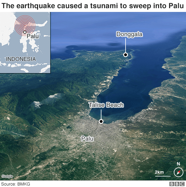
On September 28, 2018, a 7.5 earthquake in Sulawesi, triggered a powerful and destructive tsunami, which is categorized as the most serious catastrophic event of its nature since Indian Ocean 9.0 tsunami of December 26, 2004.
According to reports, there was a failure in the warning system. A BBC October 1, 2018 report recounts the events as follows:
“A 7.5 magnitude earthquake occurred just off the island of Sulawesi at 18:03 local time (10:03 GMT) on Friday, triggering dozens of aftershocks.
Indonesia’s meteorological and geophysics agency BMKG issued a tsunami warning just after the initial quake, warning of potential waves of 0.5 to three metres.
But it lifted the warning just over 30 minutes later.
Palu – a city in Sulawesi located in a narrow bay – was hit by waves as high as six metres. The surging water brought buildings down and caused widespread destruction. Hundreds of people had gathered for a beachfront festival and it was was a scene of horror as waves powered over the beach – sweeping up everything in their path.
Indonesia’s National Disaster and Mitigation Agency has said that most of the victims in Palu were killed as a result of the tsunami.
Many critics have accused BMKG of lifting the warning too early, though the agency says the waves hit while the warning was still in force.
BMKG chairwoman Dwikorita Karnawati told the Jakarta Post that the decision to end the warning was made after the agency received information about the tsunami, including a field observation made by a BMKG employee in Palu.
She added that the tsunami alert ended at 18:37, minutes after the third and last wave hit land. She also said that there were no more tsunami waves after the alert ended.”
Why did the information not get out.
There were failures in the warning system (of a different nature) both on September 28, 2018 as well as on December 26, 2004
The following article first published in February 2005 focusses on the failures of the warning system in relation to the 9.1 earthquake of December 26, 2004 which triggered the Indian Ocean tsunami.
The tsunami warning system was also examined by the author in two texts published in the immediate wake of the December 26, 2004 tsunami
Foreknowledge of a Natural Disaster , (29 Dec 2004) and
Discrepancies in the Tsunami Warning System (14 Jan 2005).
The text below examines the broader seismic network as well as the system of satellite imagery, which provides data in near real time.
The tsunami became active immediately following the earthquake. No warnings were sent out following the seismic readings despite the fact that the tsunami had already hit the Indonesian coast.
This is the key issue.
The Tsunami was active, and this was known, corroborated not only by seismic information but also by satellite images and other data, roughly 30 minutes prior to hitting Thailand.
Why was this information withheld regarding one of the most serious seismic events in recorded history?
Michel Chossudovsky, October 3, 2018
****
SUMMARY
(Scroll down for text of complete article)
One of the most destructive and powerful earthquakes in recorded history, more than a quarter of a million recorded deaths, local economies destroyed, the lives of entire communities shattered, and no serious investigation into the flaws of the global seismic warning system is contemplated.
According to Columbia University’s Earth Institute the M-9.0 Sumatra – Andaman Island earthquake on December 26th released energy, equivalent roughly to 700 million Hiroshima bombs.
Seismic information regarding what scientists identify as a “rare great earthquake”, was available in near real time (i.e. almost immediately) to seismic centers around the World.
Other types of data, including satellite imagery were also available in near real time.
The advanced global seismic information and communications systems were fully operational.
Why then, did the information not get out on the morning of December 26th?
Ten of thousands of lives could have been saved.
The issue has been skirted by the Western media, sidestepped by the governments and the UN, not to mention the international scientific community.
What Happened on the Morning of December 26th?
The tsunami was triggered within minutes of the earthquake, prior to the release of the first tsunami advisory bulletin by the Pacific Tsunami Warning Center (PTWC) in Hawaii, so it was no longer a question of emitting “a warning” of an imminent danger. The catastrophe had already happened.
In other words, by the time the first tsunami bulletin had been issued at 01.14 GMT, the deadly seismic wave was already sweeping Banda, the capital of Aceh province in Northern Sumatra, causing thousands of deaths.
This ex post facto bulletin emitted by the PTWC, did not even warn of the potential danger of a tsunami. Moreover, it casually dismissed an established and scientifically accepted relationship:
“If it were a 9 earthquake … with the thrusting in an ocean basin margin, the likelihood is almost 1:1 that it would generate a tsunami” (Dr. Charles Groat, Director, US Geological Survey in testimony to the Science Committee of the US House of Representatives, 26 Jan 2005).
Tip of the Iceberg
The PTWC bulletins are but the tip of the iceberg. The information on the quake was known and available in real time, to an entire network of seismic organizations.
It was also on hand and accessible to a number of government agencies both in the US and internationally, almost immediately. Numerous officials, scientists, members of the military and intelligence services, had advanced knowledge of an impending disaster.
In other words, we are not dealing with the failures of a single warning Center in Ewo, Hawaii, but with an entire Worldwide network of seismic information, satellite imagery and other sophisticated data, which was available almost immediately.
Who informs Whom?
The question is not why the PTWC did not emit a tsunami warning, but why did an entire global network of scientists and officials not emit a warning, in relation to one of the largest quakes in recorded history.
While the PTWC had indeed formally notified Washington and the Military at the Diego Garcia island base, the US government and military already knew, because the seismic data had been processed within minutes by an agency under the jurisdiction of the US Department of the Interior, namely the National Earthquake Information Center (NEIC) based in Golden, Colorado.
The data regarding the magnitude of the earthquake originated from four seismic stations located in the Indian Ocean, operated by the International Deployment of Accelerometers (IDA) Project .
“Received signals three minutes, thirty seconds after the quake began”
In testimony to the US Congress (Jan 26, 2005), Scripps (SIO) Deputy-Director John Orcutt which overseas the Indian Ocean IDA seismic stations confirmed that on December 26, the data pertaining to the Sumatra-Andaman quake had been “immediately and automatically forwarded by computer to the USGS National Earthquake Information Center (NEIC) in Golden, Colorado and the NOAA tsunami warning centers in Hawaii and Alaska”
The US Military Base at Diego Garcia
The first news reports underscored the fact that the US military base at Diego Garcia had been given advanced warning, but that the information reached military officials at the US island naval base “after” the tsunami had hit India and Sri Lanka:
“An NOAA log shows that the US Pacific Command, including Diego Garcia, was given a specific warning about the tsunami some two and three quarter hours after the earthquake” (The Guardian, 7 Jan 2005)
These earlier reports must be qualified. The fact of the matter, is that the data concerning the earthquake originated from monitoring stations situated in the Indian Ocean, including the The IDA/IRIS seismic station DGAR (Diego Garcia) seismic station located directly on the site of the US island military base.
Moreover, in addition to the IDA/IRIS stations, the International Monitoring System (IMS) of the Preparatory Commission for the Comprehensive Nuclear-Test-Ban Treaty Organization (CTBTO) based in Vienna, operates several stations in the Indian Ocean region, three of which are located in the Chagos Archipelago (British Indian Ocean Territory). Two of these stations are situated directly on the site of the US military base.
There are in all four monitoring stations in the Chagos archipelago, which use the communications system of the US military base.
In other words, the US military base at Diego Garcia , with its advanced monitoring facilities, research labs, etc. was not the “recipient” but rather “the source” of the relevant data regarding the earthquake.
Satellite Imagery transmitted in Real Time
In addition to real time seismic data (as well as hydroacoustic, infrasound and radionuclide data transmitted out of Diego Garcia), satellite images of the disaster on the North Sumatra coastline were also available in near real time to a number of agencies and international organizations.
The US has an advanced “spy satellite” system, with very precise capabilities of monitoring the terrain, including changes in the natural environment, not to mention moving objects. The National Reconnaissance Office (NRO), which was responsible for launching the first spy satellites of the Cold War era operates a sophisticated system of reconnaissance satellites, which transmit imagery and other data in real time.
Another key US body, involved in satellite imagery is the National Geospatial-Intelligence Agency, (NGA) , formerly known as the National Imagery and Mapping Agency. The latter was in fact the architect of the global positioning system (GPS), which was conducive to creating a system of global geospatial intelligence (GEOINT).
NGA is part of the US defense system, it serves the Department of Defense and the intelligence community. It has very precise capabilities of monitoring the geographic and physical terrain by satellite, all over the world, using the techniques of geospatial intelligence (GEOINT).
In other words, state of the art satellite imagery (available to military, intelligence, civilian as well as private commercial entities) provides “a real time set of eyes”. With regard, to the M-9.0 tsunami of December 26, satellite images were available almost immediately. The US military confirms in this regard, that it has access from its satellite systems “to vital intelligence in real time”. These real time images were used extensively in the Iraq and Afghan war theaters. (Hearings of Sen Armed Services Committee, 25 Feb 2004).
The Role of the European Space Agency
Real time seismic and other data (including satellite imagery) were also available to a number of countries including Russia, China, Japan and the European Union.
In this regard, The European Space Agency (ESA ), which has links to NOAA, has “multi-sensor access” in real time to data from satellites including very precise imagery which allows:
,em>”for complete large-scale phenomena to be observed to an accuracy and entirety it would take an army of ground level observers to match”
In addition to imagery, the satellite transmits other relevant data which measures very accurately “ground motion” and “sea height”:
While “before” and “after” images of the disaster have been made public, the images which show the progress and movement of the tsunami, in the period immediately following the earth quake have not been released.
Concluding Remarks: The Need for an Investigation into the Warning System
More than a quarter of million people have died in one of the World’s most devastating natural disasters.
The overriding issues pertaining to the warning / information systems, cannot be drowned or brushed aside. They must be the object of a full-fledged inquiry, preferably by an independent body.
This report has outlined a number of broad issues pertaining to the global information network. The latter requires detailed examination in the context of full-fledged inquiry.
What agencies in the US, the European Union, in the Indian Ocean countries and internationally were informed? The failures are by no means limited to the US seismic network.
When were they informed? What type of data did they have? Some of that data has not been released.
Why did the information not reach the people on time in the countries affected by the tsunami?
What factors, administrative, scientific or otherwise, contributed to preventing the information from being transmitted?
We are not dealing strictly with seismic data. Satellite images of the devastation in Northern Sumatra were also available. Other types of data were also transmitted in near real time by satellite.
The approximate speed of the seismic wave was known and confirmed. According to the news reports, the tsunami was moving at a speed of roughly 20 km a minute (on average) in relation to Sri Lanka.
The seismic information was known to the NEIC and other seismic centers within less than four minutes after the quake.
The tsunami hit the Indonesian coast within 5 minutes, in other words 10 minutes before the release of the first TPWC bulletin. Banda Aceh was hit by the tsunami 11 minutes after the earthquake, approximately 3 minutes before the release of the TPWC bulletin.
In other words, it was possible to predict in a very precise way, at what time the seismic wave would hit the coastlines of Thailand, Sri Lanka, India, The Maldives and Somalia. Had this information been transmitted in a consistent fashion, there would have been ample time to evacuate people from the coastal areas of Sri Lanka, India, not to mention the East coast of Africa.
There are no Ocean sensors in the Indian Ocean. But this was not the cause of the failures and omissions in the warning system.
The tsunami became active immediately following the earthquake. No warnings were sent out following the seismic readings despite the fact that the tsunami had already hit the Indonesian coast.
This is the key issue.
The Tsunami was active, and this was known, corroborated not only by seismic information but also by satellite images and other data, roughly 30 minutes prior to hitting Thailand.
Michel Chossudovsky, December 26, 2015
TEXT OF COMPLETE ARTICLE
Indian Ocean Tsunami. Why did the Information Not Get Out?
by Michel Chossudovsky
February 7, 2005
One of the most destructive and powerful earthquakes in recorded history, more than a quarter of a million recorded deaths, local economies destroyed, the lives of entire communities shattered, and no serious investigation into the flaws of the global seismic warning system is contemplated.
According to Columbia University’s Earth Institute the M-9.0 Sumatra – Andaman Island earthquake on December 26th released energy, equivalent roughly to 700 million Hiroshima bombs.
Seismic information regarding what scientists identify as a “rare great earthquake”, was available in near real time (i.e. almost immediately) to seismic centers around the World.
Other types of data, including satellite imagery were also available in near real time.
The advanced global seismic information and communications systems were fully operational.
Why then, did the information not get out on the morning of December 26th?
Ten of thousands of lives could have been saved.
The issue has been skirted by the Western media, sidestepped by the governments and the UN, not to mention the international scientific community.
The blame was casually placed on the Indian Ocean countries, described as having “inadequate communications systems”, not to mention the local people who “have to be trained to know what to do…If the people don’t respond, don’t understand what the communication is all about, it is for naught.” (Washington Times, 30Dec 2004)
What Happened on the Morning of December 26th?
The tsunami was triggered within minutes of the earthquake, prior to the release of the first tsunami advisory bulletin by the Pacific Tsunami Warning Center (PTWC) in Hawaii, so it was no longer a question of emitting “a warning” of an imminent danger. The catastrophe had already happened.
In other words, by the time the first tsunami bulletin had been issued at 01.14 GMT, the deadly seismic wave was already sweeping Banda, the capital of Aceh province in Northern Sumatra, causing thousands of deaths.
Moreover, this ex post facto bulletin emitted by the PTWC, not only failed to acknowledge an ongoing disaster, it did not even warn of the potential danger of a tsunami, when the deadly seismic wave had already started, devastating densely populated areas. (PTWC bulletins apply to the Pacific as well as regions adjacent to the Pacific. For details, see:Discrepancies in the Tsunami Warning System )
Inconsistencies in the Tsunami Bulletins
Three days earlier, on the 23d of December, a M-7.9 earthquake was recorded with an epicenter off the South Pacific MacQuarie islands The PTWC issued the following routine tsunami advisory:
“THIS EARTHQUAKE HAS THE POTENTIAL TO GENERATE A WIDELY DESTRUCTIVE TSUNAMI IN THE SEA NEAR THE EARTHQUAKE. AUTHORITIES IN THAT REGION SHOULD BE AWARE OF THIS POSSIBILITY.”
Why then in the case of a M-9.0 earthquake, which is more than ten times greater in magnitude than a M-7.9 earthquake, did the PTWC authorities fail to even issue a tsunami warning?
An event of this type and magnitude is known as a “megathrust,” which in its specific Indian Ocean location is said to occur “approximately every few hundred years.” (See Columbia University Earth Institute ).
Scientists in fact suggested that the quake had unleashed enough energy that “it could have rocked the earth off its axis.” (See: Huge quake resonates, Carolyn Y. Johnson, Boston Globe)
In other words, the least one would have expected in the case of a “megathrust” was a similar routine statement to that issued in relation to the McQuarie islands earthquake, three days earlier, on December 23. (see:Discrepancies in the Tsunami Warning System )
The first bulletin emitted on the 26th not only failed to conform to established criteria used in previous and subsequent seismic occurrences, it casually dismissed an established and scientifically accepted relationship. According to
“If it were a 9 earthquake … with the thrusting in an ocean basin margin, the likelihood is almost 1:1 that it would generate a tsunami” (Dr. Charles Groat, Director, US Geological Survey in testimony to the Science Committee of the US House of Representatives, 26 Jan 2005).
The Earthquake took place at 00.58.50 GMT on the 26th of December. Roughly five minutes later it had hit the coast of Northern Sumatra, 11 minutes after the earthquake it devastated Banda, capital of Aceh. Fifteen minutes after the earthquake, at 01.14 GMT the Pacific Tsunami Warning Center in Hawaii confirmed in its bulletin:
“THERE IS NO TSUNAMI WARNING OR WATCH IN EFFECT”
Moreover, both official and news reports out of Aceh province, following the disaster, were either delayed or were not transmitted on time.
In other words, despite the dramatic nature of the quake, the seismic information, which was available in real time, failed to reach the countries affected by the seismic wave.
Why were the countries not informed of an impending disaster?
In the words of Maine Senator Olympia Snowe:
“… what efforts, if any, were made to contact those other nations in the region that were also in harm’s way? If NOAA did not have the appropriate contacts, as has been reported, why was this the case? Was an attempt made to obtain that contact information – and if not, why not? These are questions that must be answered.”
The Western media not only failed to address the failures in the warning system, they admonished those who raised the issue.
In fact, any serious analysis of the warning system was dismissed outright.
A few press reports, nonetheless, confirmed that, with the exception of Indonesia and Australia, the Indian Ocean countries had not been informed. These same reports, largely based on statements of the Pacific Tsunami Warning system (PTWC) in Hawaii, also acknowledged that the US State Department and the Military, including the US Navy base on the island of Diego Garcia in the Chagos Archipelago had been duly notified.
In retrospect, however, these earlier press reports (including our own analysis ) need to be qualified. Published in the immediate wake of the disaster, they quote official statements to the effect that the US government and military had been informed by the PTWC, when in fact the PTWC was on the “receiving end” of the flow of seismic data. (See Foreknowledge of a Natural Disaster , Richard Norton Taylor, US island base given warning: Bulletins sent to Diego Garcia ‘could have saved lives’, The Guardian, Jan 2005).
The Information was Known to an Entire Network of Organizations
Upon closer examination, the PTWC bulletins are but the tip of the iceberg: The information on the quake was known and available in real time, to an entire network of seismic organizations. It was also on hand and accessible to a number of government agencies both in the US and internationally, almost immediately. Numerous officials, scientists, members of the military and intelligence services, had advanced knowledge of an impending disaster.
In other words, we are not dealing with the failures of a single warning Center in Ewo, Hawaii, but with an entire Worldwide network of seismic information, satellite imagery and other sophisticated data, which was available almost immediately.
Who informs Whom?
The question is not why the PTWC did not emit a tsunami warning but why did an entire global network of scientists and officials not emit a warning, in relation to one of the largest quakes in recorded history.
While the PTWC had indeed formally notified Washington and the Military at the Diego Garcia island base, the US government and military already knew, because the seismic data had been processed within minutes by an agency under the jurisdiction of the US Department of the Interior, namely the National Earthquake Information Center (NEIC) based in Golden (close to Denver), Colorado.
“The National Earthquake Information Service (NEIS) of the U. S. Geological Survey is located at the National Earthquake Information Center (NEIC) in Golden, Colorado, USA which also serves as World Data Center A for Seismology. The NEIS is a member of the Council of the National Seismic System (CNSS) which coordinates activities among the national and regional seismograph networks, including “finger quake” services. The NEIS is also closely associated with the U.S. National Seismograph Network (USNSN) and cooperates with national and international seismological organizations around the world. Unlike other members of the CNSS, the NEIS is responsible for reporting on moderate to large earthquakes throughout the U. S. and large earthquakes worldwide… On an immediate basis, all Earthquake Early Alerting Service alarm events will be made available to the “quake” list. At a minimum, this includes… most foreign earthquakes of magnitude 6.5 or greater. In practice, many foreign earthquakes smaller than a magnitude of 6.5 will also be provided on an immediate basis…”
For further details: See http://neic.usgs.gov/neis/finger/qk_info.html
,
http://neic.usgs.gov/neis/finger/qk_info.html
,
http://neic.usgs.gov/neis/bulletin/neic_slav_ts.html
,
http://neic.usgs.gov/neis/bulletin/neic_slav_ts.html
,
http://earthquake.usgs.gov/eqinthenews/2004/usslav/neic_slav_faq.html
The seismographic data did not originate at the PTWC, which is part of the Weather Service of the National Oceanic and Atmospheric Administration (NOAA) under the jurisdiction of the US Department of Commerce.
The seismic data was recorded both within the Indian Ocean region and around the World by a number of stations, relayed to a network of seismic centers in a number of countries. (see below).
In other words, omissions and failures in the warning system, not to mention red tape, were by no means limited to the PTWC, which is integrated into a global information network which records, processes and transmits seismic data in near real time. Several key organizations (including the Earthquake Information Center World Data Center for Seismology, Denver (NEIC) and The European Space Agency (ESA) among others, are part of this network, and could have duly advised the countries concerned.
Where did the seismic data originate from?
This issue, which is crucial to understanding the flaws in the seismic warning system, was barely mentioned by the media.
The data regarding the magnitude of the earthquake originated from four seismic stations located in the Indian Ocean, operated by the International Deployment of Accelerometers (IDA) Project . The Scripps Institution Of Oceanography (SIO) at the University Of California at San Diego overseas the IDA seismic stations.
In turn, the IDA is integrated into the Incorporated Research Institutions for Seismology (IRIS) and its Global Seismographic Network (GSN ), and into the data system of the National Earthquake Information Center World Data Center for Seismology, Denver (NEIC (WDCS-D)). (See Eric Waddell, The Tsunami: Why Weren’t They Warned? Jan 2005, http://globalresearch.ca/articles/WAD501A.html )
“Received signals three minutes, thirty seconds after the quake began”
In testimony to the US Congress (Jan 26, 2005), Scripps (SIO) Deputy-Director John Orcutt confirmed that “data telemetry”, namely the transfer of data immediately via phone line, cable, or satellite is central to the SIO’s mandate:
“Data acquired via telemetry may be used … as [a] :tsunami warning:… Prompt transmission of the seismic data permits experts to locate earthquakes quickly, assess the likelihood they have generated a tsunami, and predict when the destructive wave will arrive. Such predictions have already saved numerous lives.”(SIO’s Project IDA, http://ida.ucsd.edu/Telemetry/index.html )
Scripps Dr. Orcutt also confirmed that on December 26, the data pertaining to the Sumatra-Andaman quake had been telemetered from 30 IDA stations and had been “immediately and automatically forwarded by computer to the USGS National Earthquake Information Center (NEIC) in Golden, Colorado and the NOAA tsunami warning centers in Hawaii and Alaska”:
“Due to their proximity to the event, IDA stations were critical in the early detection of the December 26th earthquake. The two closest global seismic stations, IDA stations on Cocos (Keeling) Island and Sri Lanka, received signals three minutes, thirty seconds after the quake began. Data from these and other IDA GSN stations in the region were used by the NEIC, and other civil, academic, and military systems to quickly determine the quake’s size and location.” (Statement to the Science Committee of the US House of Representatives, 26 Jan 2005. emphasis added).
Contradicting the substance of his own testimony, Dr. Orcutt stated that Scripps (SIO) officials got the news from the NEIC, by email one hour and 17 minutes after the earthquake, when in fact it was the Scripps IDA stations, that had transmitted the data in near real time to the NEIC in the first place, and that this data had been made available to other agencies, in the US and internationally:
“Scripps staff first learned of the quake at 6:16 PM PST (one hour seventeen minutes after the earthquake) when they received notice via automatic email from the NEIC of the initial earthquake detection. SIO [Scripps Institution of Oceanography] also received an inquiry from the IDA/Sri Lanka operator at 6:57PM (one hour fiftyeight minutes after the quake) asking whether there had been any earthquakes in or near Sri Lanka. The operator had received many phone calls from local residents who had felt tremors and wanted to know the source. SIO’s analyst replied at 7:13PM with information about the NEIC announcement of the earthquake and a plot of the seismic waves recorded by the IDA station in Sri Lanka.” (Ibid)
Not explicitly mentioned in Dr. Orcutt’s statement is that one of the Indian Ocean IDA stations, which transmitted seismic data on December 26th, DGAR (Diego Garcia) is actually located on the site of the US military base in the Chagos Archipelago. (DGAR became operational in January 2004). The other three stations are:
COCO (Cocos [Keeling] Islands located in an Australian administered territory,
In addition to the seismic stations of the IDA/IRIS network, the quake was recorded at stations in a number of countries including China, Russia and Japan, not to mention several “auxiliary seismic stations” in Indonesia as well as one in Sri Lanka. (Parapat, Sumatera PSI Auxiliary Seismic Station AS043 2.7 98 is the closest facility to the epicenter). (See http://ida.ucsd.edu/SpecialEvents/2004/361/a/index.shtml#parameters . Auxiliary Stations as opposed to Primary stations do not transmit data in real time to the IDA)
The Chain of information
Seismographic data was transmitted in real time from the four IDA Indian Ocean stations DGAR (Diego Garcia), COCO (Cocos [Keeling] Islands , PALK (Sri Lanka), and MSEY (Seychelles) to both the IRIS and NEIC centers, where they were then immediately retransmitted (in real time) to the PTWC as well as to other agencies and organizations.
The latest station in the network established in Feb 2004 is Diego Garcia, DGAR.
Source: http://ida.ucsd.edu/IDANetwork/index.html (click map to get Station information)
In other words, while the press reports acknowledge that the Diego Garcia island military base was formally notified of the dangers of a seismic wave, what they failed to mention was that part of the seismic data used by the PTWC to justify its advisory had in fact originated in Diego Garcia, and that the data from Diego Garcia (together with that of three other Indian Ocean stations) had also been transmitted to the IDA/IRIS and NEIC networks.
The US Military Base at Diego Garcia
The IDA/IRIS seismic station DGAR (Diego Garcia) , is in a vault located on the grounds of the US Air Force’s Ground-Based Electro-Optical Deep Space Surveillance (GEODSS) station at the US military base. (The GEODSS Diego Garcia facility provides “space surveillance data” through three powerful telescopes. GEODSS also monitors moving objects and meteorites; concomitantly, it also uses seismographic data.)
The Seismic Station At Diego Garcia established in Feb 2004 transmits data to IRIS and NEIC
The seismic recording equipment installed in the underground vault. The sensors rest on the central pier, which is directly attached to the coral that underlies the vault so that the instruments can best record the shaking caused as seismic waves travel through the earth.
While DGAR was established with the cooperation of the US military, it is categorized as a civilian scientific facility. The later uses the island’s military base’s communications facilities to transmit its seismic readings to the IDA/IRIS center in Seattle.
Whether the seismographic readings from DGAR were directly available to military personnel on location at Diego Garcia at the GEODSS facility is not known, although the Diego Garcia military authorities would most probably have near real time access to the seismic data monitored by NEIC and other seismic centers, which are hooked up to the Military.
In other words, in all likelihood, the US military had the relevant data on their computer screens within minutes of its transmission.
More generally, there are close interagency links between the relevant civilian and military entities. NOAA, while formally a civilian body under the jurisdiction of the Department of Commerce, is headed by a former Vice Admiral, and NOAA Weather services, which oversees the PTWCs in Hawaii and Alaska is administered by a retired US Air Force Brig. General. (See http://www.nws.noaa.gov/johnson_bio.php )
The Monitoring System of the Comprehensive Nuclear-Test-Ban Treaty (CTBTO)
In addition to the IDA/IRIS stations, the International Monitoring System (IMS) of the Preparatory Commission for the Comprehensive Nuclear-Test-Ban Treaty Organization (CTBTO) based in Vienna, operates several stations in the Indian Ocean region, three of which are in fact located in the Chagos Archipelago (British Indian Ocean Territory). (See map below) Two of these stations are situated directly on the site of the US military base. In other words, there are in all four stations in the Chagos archipelago, which use the communications system of the US military base.
The IMS confirmed that it recorded the December 26th earthquake at 78 of its stations, including those in the Indian Ocean in near real time, “within seconds to minutes of the event.” (of the 78 IMS stations, 71 were using the seismic, six the hydroacoustic and one the infrasound technologies. The latter (infrasound station) was located within proximity of the Diego Garcia military base in the Chagos Archipelago.
The CTBTO confirms in this regard that “the first automatic event list containing the Sumatra earthquake was released by the International Data Center (IDC) in Vienna two hours after the event.” It nonetheless confirms that the “raw data from the monitoring stations” were communicated “in near real time” ( almost immediately) to national data centers of state signatories including Australia, Indonesia and Thailand. (See text of CTBTO Press Release ).
Four Monitoring Stations in the Chagos Archipelago
The first news reports underscored the fact that the US military base at Diego Garcia had been given advanced warning, but that the information reached military officials at the US island naval base “after” the tsunami had hit India and Sri Lanka:
“An NOAA log shows that the US Pacific Command, including Diego Garcia, was given a specific warning about the tsunami some two and three quarter hours after the earthquake” (The Guardian, 7 Jan 2005)
The fact of the matter, as mentioned earlier, is that the data concerning the earthquake originated from monitoring stations situated on the site of the US island military base. In other words, the US military base at Diego Garcia , with its advanced monitoring facilities, research labs, etc. was not the “recipient” but rather “the source” of the relevant data regarding the earthquake. (See Table 1).
It is the source not only of seismic information (not to mention satellite imaging) but of other types of data, used to ascertain the causes of an earthquake, from three other monitoring stations in the Chagos islands, which are linked up to the IMS/ CTBTO :
BIOT/Chagos Radionuclide Station (RN66) at Diego Garcia military base is a radionuclide station which monitors traces of radioactivity in the Indian Ocean basin
BIOT/Chagos Hydroacoustic Station (HA08)(Diego Garcia military base ), which has the ability of “detecting explosions on the ocean surface and under the water”
the BIOT/Chagos Infrasound Station (IS52) (located North of Diego Garcia, see map below) which “provides evidence of a possible atmospheric explosion by detecting sound pressure waves in the atmosphere”.
(see http://pws.ctbto.org/verification/facilities/monfacoutput.dhtml?&vcol=a.name&vord=desc )
The Vienna based IMS also had relevant information, within minutes of the M-9.0 earthquake. To date, none of the data recorded at its Indian Ocean stations has been made public, although it is normally transmitted to the signatory governments and is no doubt also available to the US military.
The functions of these three IMS stations under the CTBTO mandate are as follows:
“The IMS uses seismic, hydroacoustic and infrasound monitoring technologies to detect the transient signals created when the energy is released in underground, underwater and atmosphere environments, respectively. Radionuclide monitoring technologies collect and analyze air samples for evidence of the physical products created and carried by the winds. Seismic, hydroacoustic and infrasound, or the wave technologies, all utilize sensors which record signals from explosions and naturally occurring events in the form of digital waveforms. These digital waveforms or time series provide diagnostic information to detect, locate and characterize the energy source. Radionuclide technology is based on air samplers which collect and analyse atmospheric particulate matter deposited on collection filters. The analysis of the radionuclide content uniquely confirms the fact of a nuclear explosion.”
(For further details see, CBTO, The Global Verification Regime and the International Monitoring System, Vienna, 2001 http://pws.ctbto.org/reference/outreach/booklet3.pdf )
In other words, the data collected by the three Chagos islands IMS stations have the capacity of “registering shock waves emanating from a nuclear explosion underground, in the seas and in the air, as well as detecting radioactive debris released into the atmosphere.”
This data could shed light on the nature of the disaster, while also dispelling speculation by some news media that the tsunami could have been caused by an underground explosion.
It is therefore crucial that the readings from these three BIOT IMS stations, which are available to the signatory governments, be promptly released and analyzed.
Map of Diego Garcia Military Base and Chagos archipelago
Click image to enlarge
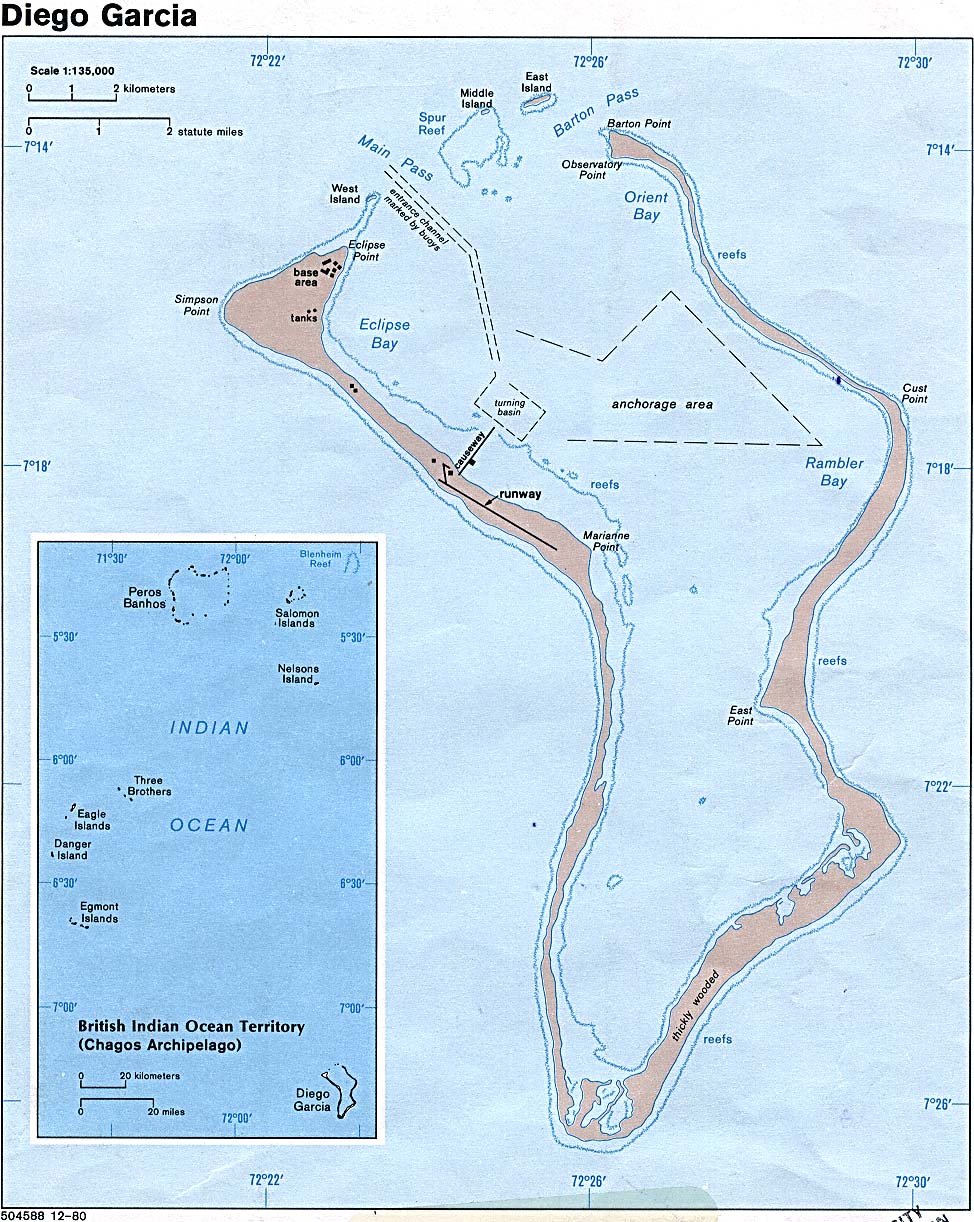
http://www.lib.utexas.edu/maps/islands_oceans_poles/diego_garcia_pol80.jpg
In addition to real time seismic data (as well as hydroacoustic, infrasound and radionuclide data), satellite images of the disaster on the North Sumatra coastline were also available in near real time to a number of agencies and international organizations.
The US has an advanced “spy satellite” system, with very precise capabilities of monitoring the terrain, including changes in the natural environment, not to mention moving objects. The National Reconnaissance Office (NRO), which was responsible for launching the first spy satellites of the Cold War era operates a sophisticated system of reconnaissance satellites, which transmit imagery and other data in real time.
The data received by the NRO are relayed to a number of US government/ military bodies including the Department of Defense and the CIA.
As part of its mandate, the NRO has the ability to:
” warn of potential trouble spots around the World, help plan military operations and monitor the environment”
The NRO has close links to the Diego Garcia base from which it operates “The Global Broadcast System”, a special classified broadband communication system. “A GBS satellite parked above the Indian Ocean island of Diego Garcia relayed everything from video feeds of Predator UAVs, to video downlinks for special operations soldiers on horseback in remote regions of western Afghanistan.” ( See http://www.globenet.free-online.co.uk/articles/spacesupremacy.htm )
Another key US body, involved in satellite imagery is the National Geospatial-Intelligence Agency, (NGA) , formerly known as the National Imagery and Mapping Agency. The latter was in fact the architect of the global positioning system (GPS), which was conducive to creating a system of global geospatial intelligence (GEOINT).
NGA is part of the US defense system, it serves the Department of Defense and the intelligence community. It has very precise capabilities of monitoring the geographic and physical terrain by satellite, all over the world, using the techniques of geospatial intelligence (GEOINT).
Geospatial intelligence is described by the NGA as:
“the most valuable tool for envisioning and predicting activity around the World. It serves anyone from the White House to the pilothouse, from the Situation room to the ready room”
In other words, state of the art satellite imagery (available to military, intelligence, civilian as well as private commercial entities) provides “a real time set of eyes”. With regard, to the M-9.0 tsunami of December 26, satellite images were available almost immediately. The US military confirms in this regard, that it has access from its satellite systems “to vital intelligence in real time”. These real time images were used extensively in the Iraq and Afghan war theaters. (Hearings of Sen Armed Services Committee, 25 Feb 2004).
The European Space Agency
Real time seismic and other data (including satellite imagery) were also available to a number of countries including Russia, China, Japan and the European Union.
In this regard, The European Space Agency (ESA ), which has links to NOAA, has “multi-sensor access” in real time to data from satellites including very precise imagery which allows:
“for complete large-scale phenomena to be observed to an accuracy and entirety it would take an army of ground level observers to match”
According to ESA ,
” a single satellite image has the potential to show the spread of air pollution across a continent, the precise damage done to a region by an earthquake or a forest fires, or the entire span of a 500 km, hurricane from the calmness of its eye to its outermost storm fronts. The same space based sensor gathers data from sites across the World, including places too remote or otherwise inaccessible for ground based data acquisition.”
In addition to imagery, the satellite transmits other relevant data which measures very accurately “ground motion” and “sea height”:
“Other sensors known as radar instruments actively shine microwaves pulses down to Earth in order to record how these pulses get reflected back up to space.
These instruments measure surface roughness instead of light or heat energy, and have the advantage of being able to see through cloud and darkness. And by combining together different radar images of the same location – a technique known as interferometry – tiny millimeter-scale ground motion can be identified.
A different type of instrument named an altimeter records very precisely the time it takes for a microwave or laser pulse to be bounced back to the satellite, measuring both land and sea height to an accuracy of a few centimetres.“(http://www.esa.int/export/esaEO/SEMH2Q1VQUD_index_0.html )
The European Space Agency (ESA) is part of a network. It is a member of the International Charter: Space and Major Disasters along with the Centre national d’études spatiales (CNES), the Canadian Space Agency (CSA), the Indian Space Research Organisation (ISRO), the National Oceanic and Atmospheric Administration (NOAA) and Argentina’s Comisión Nacional de Actividades Espaciales (CONAE)
While “before” and “after” images of the disaster have been made public, the images which show the progress and movement of the tsunami, in the period immediately following the earth quake have not been released.
Concluding Remarks: The Need for an Investigation into the Warning System
More than a quarter of million people have died in one of the World’s most devastating natural disasters.
The overriding issues pertaining to the warning / information systems, cannot drowned or brushed aside. They must be the object of a full-fledged inquiry, preferably by an independent body.
This report has outlined a number of broad issues pertaining to the global information network. The latter requires detailed examination in the context of full-fledged inquiry.
What agencies in the US, the European Union, in the Indian Ocean countries and internationally were informed? The failures are by no means limited to the US seismic network.
When were they informed? What type of data did they have? Some of that data has not been released.
Why did the information not reach the people on time in the countries affected by the tsunami?
What factors, administrative, scientific or otherwise, contributed to preventing the information from being transmitted?
We are not dealing strictly with seismic data. Satellite images of the devastation in Northern Sumatra were also available. Other types of data were also transmitted in near real time by satellite.
In addition to the seismic data, the Vienna based IMS/CTBTO monitors and compiles hydroacoustic, infrasound and radionuclide data, which is transmitted in near real time from its stations in the Indian Ocean (including three stations in the Chagos islands archipelago).
Moreover, satellite reconnaissance technology, not to mention the use of simulation models, have the ability to assess and monitor the speed of the tsunami in near real time.
The approximate speed of the seismic wave was known and confirmed. According to the news reports, the tsunami was moving at a speed of roughly 20 km a minute (on average) in relation to Sri Lanka.
The seismic information was known to the NEIC and other seismic centers within less than four minutes after the quake.
The tsunami hit the Indonesian coast within 5 minutes, in other words 10 minutes before the release of the first TPWC bulletin. Banda Aceh was hit by the tsunami 11 minutes after the earthquake, approximately 3 minutes before the release of the TPWC bulletin.
In other words, it was possible to predict in a very precise way, at what time the seismic wave would hit the coastlines of Thailand, Sri Lanka, India, The Maldives and Somalia. Had this information been transmitted in a consistent fashion, there would have been ample time to evacuate people from the coastal areas of Sri Lanka, India, not to mention the East coast of Africa.
There are no Ocean sensors in the Indian Ocean. But this was not the cause of the failures and omissions in the warning system.
The tsunami became active immediately following the earthquake. No warnings were sent out following the seismic readings despite the fact that the tsunami had already hit the Indonesian coast.
This is the key issue.
The Tsunami was active, and this was known, corroborated not only by seismic information but also by satellite images and other data, roughly 30 minutes prior to hitting Thailand.
Annex
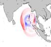
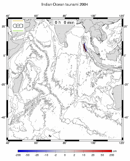
Map: Animation Simulating the propagation of the Tsunami in the Indian Ocean .
Approximate Timeline
(based on News Reports published in the immediate wake of the earthquake)
Sunday 26 December 2004 (GMT)
00.58.50 GMT: a 9.0 magnitude earthquake occurs on the seafloor near Aceh in northern Indonesia.
01.02.20 GMT: IDA seismic stations in the Indian Ocean transmit data to the IRIS/IDA network and the National Earthquake Information Center World Data Center for Seismology, Denver(3 min 30 sec. after the earthquake)
Shortly after 01.00 GMT: Earthquake hits several cities in Indonesia, creates panic in urban areas in peninsular Malaysia. The news of the earthquake is reported immediately.
01.04 GMT the tsunami hits the coast of Northern Sumatra ( roughly 5 min after the earthquake)
01.10 minutes after the earthquake it devastated Banda, capital of Aceh. (11 minutes after the earthquake)
01.14 GMT: The Pacific Tsunami Warning Center in Hawaii emits its first bulletin, confirming that there is no tsunami warning in effect.
01.3O GMT: Phuket and Coast of Thailand: The tidal wave hits the coastline after 8.30 am, 01.30 GMT
02:16 GMT (one hour seventeen minutes after the earthquake). SIO staff received notice via automatic email from the NEIC of the initial earthquake detection.
02.30 GMT: Eastern Coast of Sri Lanka is hit. The seismic wave hits the coastal regions close to the capital Colombo, according to report at 8.30 am local time, 02.30 GMT (approximately, an hour and a half after the earthquake)
02:57 PM: One hour fifty-eight minutes after the quake, SIO staff receive request from Sri Lanka “asking whether there had been any earthquakes in or near Sri Lanka.” (By that time the tsunami had already devastated the coast of Sri Lanka).
02.45 GMT: India’s Eastern Coastline. The tsunami hits India’s eastern coast as of 6:15 a.m.(02:45 GMT)
0.3.43 GMT: NOAA log indicates that US Pacific Command, including the Diego Garcia military base, were “given a specific warning about the tsunami some two and three quarter hours after the earthquake” (The Guardian, 7 Jan 2005). Subsequent reports suggest that the Military received the seismic data in near real time shortly after the earthquake.
04.00 GMT: Male, Maldives: From about 9:00 am (04.00 GMT), three hours after the earthquake, the capital, Male, and other parts of the country were flooded by the tsunami. (more than three hours after the earthquake)
08.00 -11.00 GMT (according to news dispatches): East Coast of Africa is hit. Seven to ten hours after the earthquake (see animated map).
Table 1
FOUR MONITORING STATIONS IN THE BIOT CHAGOS ARCHIPELAGO
1. IDA/ IRIS DGAR (Diego Garcia), Seismometer on the site of the US Air Force’s Ground-Based Electro-Optical Deep Space Surveillance (GEODSS) station at Diego Garcia. -7.3 S 72.4 E
2. IMS/ CTBTO BIOT Chagos Hydroacoustic Station (HA08) at -7.3 S 72.4 E located at the Diego Garcia US military base
3. IMS/ CTBTO BIOT Chagos Radionuclide Station (RN66) at -7.0 S 72.0 E located at the Diego Garcia US military base.
4. IMS/ CTBTO BIOT Chagos Infrasound Station (IS52) at -5.0 S 72.0 E located near Peros Banhos Island
The IMS stations transmit data in real time to the CTBTO International Data Centre (IDC) in Vienna, The IDa station transmits data in real to IRIS and NEIC
Functions of CTBTO International Monitoring System
- The primary and auxiliary seismic stations monitor seismic signals propagating through the earth from natural events (earthquakes) and man-made events (mining blasts and explosions);
- The radionuclide stations pick up traces of radioactivity following a nuclear explosion in the atmosphere or leaked from an underground nuclear test;
- The hydroacoustic stations detect explosions on the ocean surface and under the water; and
- The infrasound stations provide evidence of a possible atmospheric explosion by detecting sound pressure waves in the atmosphere.
Source: FAS
Table 2 IDA Project Links to Seismographic Readings
- Location map
- Initial source parameters
- 3 components [closest IDA station, COCO, clipped]
- 3 components [closest IDA station, COCO, non-clipped]
- 3 components [next closest IDA station, PALK, non-clipped]
- 3 components [3rd closest IDA station, DGAR, non-clipped]
- All IDA stations, vertical components, filtered
- All IDA stations, vertical components, low pass fliter
- Plot showing the accelerations observed at IRIS/IDA stations COCO and PALK superimposed on a figure depicting expected ground accelerations for varying distances and sizes of earthquake.
Source: IDA Project. Magnitude 9.0 quake off the west coast of Northern Sumatra (click to access the relevant data)
http://ida.ucsd.edu/SpecialEvents/2004/361/a/index.shtml#parameters
Figure 1: Seismographic readings for Dec 26, 2005 at Diego Garcia DGAR

click image to enlarge
Source: Project IDA, http://ida.ucsd.edu/SpecialEvents/2004/361/a/DGARunclip.gif
Table 3:
480 Stations sorted by distance from the epicenter recorded the seismic data
IRIS ONLINE DATA ON WILBER II
Event: 2004/12/26 00:58:50.7 OFF W COAST OF NORTHERN SUMATERA
(CLICK TO ACCESS EVENT, SELECT STATIONS AND PROCEED)
Mag: 8.5 Type: MS Lat: 3.30 Lon: 95.78 Depth: 10.00
Catalog: NEICALRT Contributor: NEIC Source: SPYDER®
Source: Wilber II
Table 4:
2004/12/26 00:58:50. First Four Responding Stations Sorted by Distance from the Epicenter (click station name to access seismographic readings)
name.net (distance/azimuth)
COCO.II (15.42°/176°) Coco Islands, Australia
PALK.II (15.52°/285°) Pallekele, Sri Lanka
QIZ.IC (20.82°/40°) Guandong Province, China
DGAR.II (25.60°/245°) Diego Garcia, BIOT
Source: Wilber II
The Global Tsunami Warning System
While the PTWC failed to acknowledge the existence of the tsunami in its first two bulletins, the Tsunami was in fact monitored in real time by a number of monitoring stations of the National Oceanic and Atmospheric Administration (NOAA) to which the PTWC belongs.
Modeling enabled scientists to evaluate the traveling time of the tsunami. From the outset of the earthquake at 00.59 UTC on the 26th, tsunami waves were monitored by a number of stations. Moreover, NOAA has acknowledged that it had very precise satellite images which enables it to measure the height of the tsunami. These height measurements were available but were only processed at a later period (See http://www.noaanews.noaa.gov/stories2005/s2365.htm )

NOAA: Tsunami Height Measurements (satellite) click to enlarge
Related Global Research Articles
Foreknowledge of a Natural Disaster: Washington was aware that a deadly Tidal Wave was building up in the Indian Ocean, Michel Chossudovsky
The Tsunami: Why Weren’t They Warned? Eric Waddell
Discrepancies in the Tsunami Warning System, Michel Chossudovsky
US island base given warning: Bulletins sent to Diego Garcia ‘could have saved lives’ Richard Norton-Taylor
Links to important sources of information:
Columbia University Earth Institute
Incorporated Research Institutions for Seismology (IRIS) , Washington D.C
IRIS network of 128+ (often unmanned) seismic monitoring stations worldwide.
International Deployment of Accelerometers (IDA)
IDA stations in the Indian Ocean:
The National Earthquake Information Center (NEIC)
World Data Center of the National Earthquake Information Center in Denver, USA.
Institute of Geophysics and Planetary Physics , University of California, San Diego,
USGS United States Geological Survey
National Oceanic and Atmospheric Agency (NOAA)
NOAA: West Coast/Alaska Tsunami Warning Center: Indian Ocean Tsunami of 26 December, 2004
NOAA Pacific Tsunami Warning Center, PTWC
NOAA West Coast & Alaska Tsunami Warning Center, WCATWC
Map of IMS Facilities (takes time to download)
IISSE: Off Coast of Northern Sumatra Earthquake (Japan)
İstanbul Technical University, Department of Geophysical Engineering, Seismology Section
On Satellite Imagery
The European Space Agency (ESA )
The National Reconnaissance Office (NRO)
National Geospatial-Intelligence Agency, (NGA)
Natural Hazards Research Websites
Satellite Images, Data and Information Websites
Earth Observing System, Direct Broadcast
Earth Observing System Data Gateway
Earth Observation Imagery Disasters
QUAKELINE: bibliographic database produced by the MCEER Information Service . It covers earthquakes, earthquake engineering, natural hazard mitigation, and related topics. It includes records for various publication types, such as journal articles, conference papers, technical reports, maps, and videotapes.
Wilber II IRIS Event: 2004/12/26 00:58:50.7
International Charter: Space and Major Disasters
The International Charter aims at providing a unified system of space data acquisition and delivery to those affected by natural or man-made disasters through authorized users. Each member agency has committed resources to support the provisions of the Charter and thus is helping to mitigate the effects of disasters on human life and property.
View PDF of the Charter Pamphlet The International Charter was declared formally operational on November 1, 2000. An authorized user can now call a single number to request the mobilization of the space and associated ground resources (RADARSAT, ERS, SPOT) of the three agencies to obtain data and information on a disaster occurrence
Participating Agencies and Space Resources
The following Space Agencies are currently members of the Charter. Click on the name for more information about the Agency and its space resources.
Member
Space Resources
European Space Agency (ESA)
ERS, ENVISAT
Centre national d’études spatiales (CNES)
SPOT
Canadian Space Agency (CSA)
RADARSAT
Indian Space Research Organisation (ISRO)
IRS
National Oceanic and Atmospheric Administration (NOAA)
POES, GOES
Argentina’s Comisión Nacional de Actividades Espaciales (CONAE)
SAC -C
International Charter: Tsunami 26 December (click for specific details)
Provides satellite images, before and after.
The images showing the progress of the tsunami on the 26th of Dec, obtained in near real time have not been released.
ESA (European Space Agency) Earth Observation, Earthnet Online
Indonesia – Sri Lanka – Thailand – India
Earthquake/Tsunami – 26 December 2004Envisat Altimetry
ENVISAT Radar Altimeter contribution
(Click on the thumbnail to enlarge the preview image)
For more information, please click here: http://www-dase.cea.fr

![3 components [closest IDA station, COCO, clipped]](http://ida.ucsd.edu/SpecialEvents/2004/361/a/COCO_closest_clipped.gif)
![3 components [closest IDA station, COCO, non-clipped]](http://ida.ucsd.edu/SpecialEvents/2004/361/a/COCOunclip.gif)
![3 components [next closest IDA station, PALK, non-clipped]](http://ida.ucsd.edu/SpecialEvents/2004/361/a/PALKunclip.gif)
DOSSIERS DE LA TERRE ET ENVIRONNEMENT (FRANCE) at http://www-dase.cea.fr/actu/dossiers_scientifiques/2004-12-26/index.html
EMSC Study:
European Mediterranean Seismological Centre
Mw 8.9 earthquake in Sumatra on December 26th, 2004 at 00:58 UTC (Click for report)
University of Evora Study:
Source Rupture Process of Mw 9.0 26/12/2004 Sumatra earthquake
Earthquake (Mw=8.9) of 26 December 2004
Preliminary Results
José Fernando Borges, Bento Caldeira and Mourad Bezzeghoud