Interference by Unnamed “Foreign Powers” in Canada’s Elections? The Invasion of “America’s Backyard”


***
US-Canada relations have not been an issue for meaningful debate in the 2019 Canada elections campaign. Ottawa complies with Washington’s foreign policy agenda. None of the major parties has addressed the issue in the course of the election campaign.
A “fake initiative” was launched by the Trudeau government to identify “foreign intervention” in our electoral process without acknowledging that the only country which has actively intervened in our politics is the United States.
And that means that Canada’s participation in US led wars is not an issue for debate by the leaders of major of political parties.
***
…. Former Russian troll Vitaly Bespalov thinks the Russians have already come up with new ways to meddle with our political views. After being implicated for interfering in the 2016 U.S. presidential campaign, they have to be more creative as Canadians get ready to go to the polls.
“So now I think they are going to invent some other schemes of influencing the audience. It will be done in a different way. No need to look for trolls on Facebook, they will find a new way.”

And I am not referring to former president Obama’s recent statement in support for Justin Trudeau.

Washington is on record of having interfered in elections in 45 countries according to political scientist Dov H. Levin of Carnegie Mellon University. 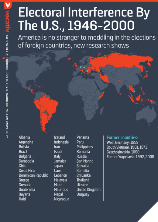
While Canada is not mentioned in Don H Levin’s study, the history of US interference in Canada’s internal affairs goes far beyond the process of meddling in Canadian elections.
Canadian farmers are acutely aware of how the Trump administration in 2017 imposed without real negotiation, a complete overhaul of trade and investment relations leading to the formation of the so-call United States, Mexico, Canada USMCA trade agreement which is intended to replace NAFTA.
Politicians in the Trudeau government were coopted. The economic impacts of this agreement on Canada’s economy are potentially devastating.
But there is much more in our history which has a direct bearing on national sovereignty and democracy in Canada. While US interventionism is part of our history, US-Canada relations are not an issue for debate in the election campaign.
Flashback to 1930…
America’s Plan to Invade Canada
While the US plan to Annex Canada in 1866 (a de facto act of war formulated as a Bill by the US Congress) is on record, most Canadians are unaware that the US in the late 1920s had formulated a detailed plan to invade Canada, entitled “Joint Army and Navy Basic War Plan — Red”. The plan was approved by the US War Department under the presidency of Herbert Hoover in 1930.
 It was updated in 1934 and 1935 during the presidency of Franklin D. Roosevelt. It was withdrawn in 1939 following the outbreak of the Second World War. (The full text of the 1935 Invasion Plan is in Annex)
This insidious military agenda which was intent on ultimately annexing Canada to the US as well as disabling the British Empire, involved the planned bombings of four major cities: Vancouver, Montreal, Quebec City and Halifax.
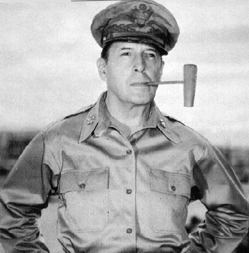
And guess who was assigned to oversee these bombings: General Douglas MacArthur (image left, 1940s), who was US Army chief of staff (1930-37). MacArthur’s mandate coincided with the release of the 1930 and 1935 invasion plan of Canada. As we recall MacArthur was subsequently put in charge of leading the bombing raids against Japan during World War II. (See Floyd Rudman)
The 1935 plan to invade Canada consisted of a 94-page document “with the word SECRET stamped on the cover.” It had been formulated over a period of over five years (See full text in Annex).
In February 1935, the [US] War Department arranged a Congressional appropriation of $57 million dollars to build three border air bases for the purposes of pre-emptive surprise attacks on Canadian air fields. The base in the Great Lakes region was to be camouflaged as a civilian airport and was to “be capable of dominating the industrial heart of Canada, the Ontario Peninsula” (from p. 61 of the February 11-13, 1935, hearings of the Committee on Military Affairs, House of Representatives, on Air Defense Bases (H.R. 6621 and H.R. 4130). This testimony was to have been secret but was published by mistake. See the New York Times, May 1, 1935, p. 1.
In August 1935, the US held its largest peacetime military manoeuvres in history, with 36,000 troops converging at the Canadian border south of Ottawa, and another 15,000 held in reserve in Pennsylvania. The war game scenario was a US motorized invasion of Canada, with the defending forces initially repulsing the invading Blue forces, but eventually to lose “outnumbered and outgunned” when Blue reinforcements arrive. This according to the Army’s pamphlet “Souvenir of of the First Army Maneuvers: The Greatest Peace Time Event in US History” (p.2). ( Professor F.W. Rudmin Queen’s University Kingston, Ontario, Comments on “War Plan Red”,
One of the updates to the 1930 invasion plan was the use of chemical weapons against civilians:
“In 1934, War Plan Red was amended to authorize the immediate first use of poison gas against Canadians and to use strategic bombing to destroy Halifax if it could not be captured.” (Ibid)
It is worth noting that in the course of World War II, a decision was taken by the War Department to retain the invasion plan on the books. War Plan Red was declassified in 1974.
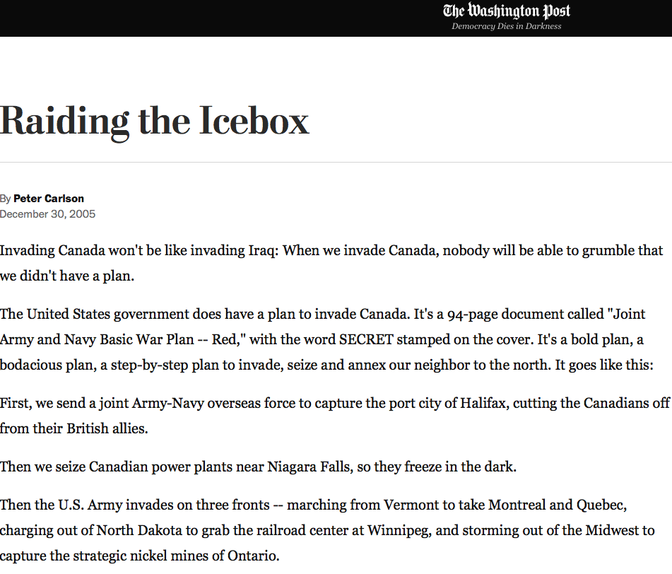
Raiding the Icebox. How the US Media Trivializes History
The Washington Post, which casually dismissed the historical significance of “Joint Army and Navy Basic War Plan — Red”, nonetheless acknowledged the aggressive nature of the proposed military endeavor:
“A bold plan, a bodacious plan, a step-by-step plan to invade, seize and annex our neighbor to the north. …First, we send a joint Army-Navy overseas force to capture the port city of Halifax, cutting the Canadians off from their British allies.
Then we seize Canadian power plants near Niagara Falls, so they freeze in the dark.
Then the U.S. Army invades on three fronts — marching from Vermont to take Montreal and Quebec, charging out of North Dakota to grab the railroad center at Winnipeg, and storming out of the Midwest to capture the strategic nickel mines of Ontario.
Meanwhile, the U.S. Navy seizes the Great Lakes and blockades Canada’s Atlantic and Pacific ports. … “(Raiding the Icebox; Behind Its Warm Front, the United States Made Cold Calculations to Subdue Canada, by Peter Carlson, Washington Post, 30 December 2005, emphasis added)
SUPPLEMENT NO. 3
TO
REPORT OF COMMITTEE NO. 8
SUBJECT:
CRITICAL AREAS OF CANADA AND APPROACHES THERETO
_______________________________________________
.
Prepared by:
SUBCOMMITTEE NO. 3
Major Charles H. Jones, Infantry, Chairman.
Lt. Col. H.W. Crawford, Engineers.
I. Papers Accompanying.
___________________
1. Bibliography. (Omitted, filed in Rec.Sec.)
2. List of Slides. "
3. Appendices (1 and 2). "
4. Annexes. (Incl. A,B,C,D,E,F,G,H,K, and L) "
II. The Study Presented.
___________________
Determine under the geographical factor, the critical areas in
Crimson (Canada) and the best approaches thereto for Blue. A critical
area is assumed to be any area of such strategic importance to either
belligerent that control thereof may have a material bearing on the out-
come of the war.
III. Facts bearing on the study.
__________________________
1. General Considerations:
An area in Crimson territory may be of strategic importance from
the viewpoint of tactical, economic, or political considerations. In the
final analysis, however, critical areas must be largely determined in the
light of Red's probable line of action and Crimson's contribution to that
effort.
2. Geographical Features of Canada.
a. Location and extent. The location and extent of the Dominion of
_
Canada is shown on the Map herewith (see Exhibit A). It comprises the
entire northern half of the the North American continent, excepting only
Alaska and the coast of Labrador, a dependency of the colony of New-
foundland.
The principal political subdivisions are those located along the
border of the United States. These from east to west are:
(1) The Maritime Provinces:
Prince Edward Island.
Nova Scotia.
New Brunswick.
(2) Quebec.
(3) Ontario.
(4) The Prairie Provinces:
Manitoba.
Saskatchewan.
Alberta.
-41-
(5) British Columbia.
Newfoundland, while not a part of the Dominion of Canada, would
undoubtedly collaborate in any Crimson effort.
b. Topography. (Slide 14852)
_
The great area in eastern Canada underlain by rocks of Precambrian
age is known as the Canadian Shield. Its northern boundary crosses the
Arctic archipelago; the eastern boundary lies beyond Baffin Island and
Labrador, and reaches the depressed area occupied by the St. Lawrence, a
short spur crossing this valley east of Lake Ontario to join the Adirondack
Mountains of New York. The southern boundary runs from this spur west to
Georgian Bay thence along the north shore of Lake Huron and Lake Superior,
thence northwest from the Lake of the Woods to the western end of Lake
Athabaska. Its average elevation does not exceed 1500 feet. The greatest
known elevations are in the eastern part of Baffin Island and along the
coast of northern Labrador. Peaks of the Torngat Mountains of Labrador
have elevations of between 4000 and 5000 feet. The coast is one of the
boldest and most rugged in the world, with many vertical cliffs rising
1000 to 2000 feet high. Occasional exceptions occur in which there are
reliefs of several hundred feet, as in the hills along the north shore of
Lake Huron and Lake Superior. The area is dotted with lakes, large and
small, and of irregular outline. A lowland of considerable extent
stretches for some distance into Ontario and Manitoba from Hudson Bay.
Extending south and west form the Canadian Shield, between the Ap-
palachian Mountains on the east and the Cordilleras on the west, lies the
Great North American plain. The northeastern portion of this plain called
the St. Lawrence lowlands occupies southern Ontario, south of a line ex-
tending from Georgian Bay to the east end of Lake Ontario; eastern Ontario
lying between the Ottawa and St. Lawrence rivers, and that part of Quebec
lying adjacent to the St. Lawrence between Montreal and Quebec.
The plain west of the Canadian Shield, known as the Interior Plains,
stretches northward to the Arctic Ocean between a line approximately join-
ing Lake Winnipeg and Lake Athabasca, Great Slave Lake and Great Bear Lake
on the east, and the foothills of the Rocky Mountains on the west.
That part of the St. Lawrence Lowlands lying in the eastern angle of
Ontario, and in Quebec south of Montreal and extending down the St. Law-
rence is comparatively flat and lies less than 500 feet above sea level.
On the lower St. Lawrence it is greatly narrowed by the near approach of
the Appalachian system to the Canadian Shield. The part lying adjacent to
Lakes Ontario, Erie and Huron is of less even surface, has its greatest
elevation of over 1700 feet south of Georgian Bay and slopes gently to
the Great Lakes.
The Interior Plains region is in general rolling country with broad
undulations and a slope eastward and northward of a few feet per mile,
descending from an elevation of 3000 to 5000 feet near the mountains on the
west to less than 1000 feet at the eastern border. The rolling character
of the area is relieved by several flat topped hills, by flat areas that
formed the beds of extensive lakes, and by deep river valleys.
The Appalachain and Arcadian regions occupy practically all that part
of Canada lying east of the St. Lawrence, with the exception of the lowlands
west of a line joining Quebec City and Lake Champlain. The Applachain
region is a continuation into Quebec of three chains of the Applachain
system of mountains. The most westerly of these ranges, the Green Mountains
of Vermont, stretches northeast into the Gaspe peninsula, where it forms
flat topped hills some 3000 feet high. The Acadian region, which includes
-42-
New Brunswick, Nova Scotia and Prince Edward Island is an alternation of
upland with hills and ridges rising 2500 feet and higher. Adjacent to the
Bay of Fundy is a series of ridges rising in places to 1200 feet. Between
these two New Brunswick uplands, which converge toward the southwest is a
lowland forming the whole eastern part of the province. This lowland ex-
tends east to include Prince Edward Island, the western fringe of Cape
Breton Island and the mainland of Nova Scotia north of the Cobequid moun-
tains, which have an elevation of 800 to 1000 feet. South of the Cobequid
Mountains lies a long narrow lowland stretching from Chedabucto Bay to
Minas Basin, and along the Cornwallis Annapolis valley between North and
South Mountains. South of this lowland is a highland sloping to the Atlantic
Coast. The northern part of Cape Breton Island is a tableland 1200 feet
high with its central part rising to an elevation of over 1700 feet.
The Cordelleran region, a mountainous area bordering the Pacific
extends from the United States through Canada into Alaska and embraces
nearly all of British Columbia and Yukon and the western edge of Alberta
and the Northwest Territories. The eastern part of the Cordillera is occu-
pied by the Rocky Mountains, with peaks rising to 10,000 feet and 12,000
feet. They extend northwest and fall away towards the Liard River. The
western part of the Cordillera is occupied by the Coast Range and the
mountains of Vancouver and Queen Charlotte Islands. The Coast Range rises
to heights of 7000 to 9000 feet. Between the Rocky Mountains and the Coast
Range lies a vast plateau 3000 to 4000 feet high and cut by deep river
valleys.
3. Population.
According to the census of 1931, the total population on June 1, 1931
was 10,376,786, of whom 5,374,541 were males. The inhabited areas of the
Dominion are essentially confined to a narrow strip along the United States
boundary, generally south of the 56th parallel of latitude west of the Lake
Winnipeg, and south of the 49th parallel of latitude east of Lake Superior.
Approximately 10% of the total population are found in the Maritime provinces,
61% in Quebec and Ontario, 23% in the Prairie Provinces and 6% in British
Columbia.
Of the present population, 51.86% are of British descent, 28.22%
French, and the remainder of widely scattered nativity.
4. Climate.
The climate of southern Canada is comparable to that of the northern
tier of the states of the United States. The west coast of British Columbia
tempered by the Pacific Ocean is mild and humid. The prairie provinces
generally experience extreme cold weather from November to March, with heavy
snow fall. The climate of southern Ontario, the St. Lawrence Valley and the
Maritime Provinces is much milder that that of the prairie provinces, but
freezing temperatures are general between the end of November and the first
of April, and the ground is usually covered with between one and three
feet of snow. Any extensive military operations in Canada between November
1st and April 15th would be extremely difficult, if not impossible.
5. Communications.
a. Railways.
_
There are only two railway systems in Canada, both crossing Canada
east and west from the Atlantic to the Pacific. These lines generally
parallel the United States border, in some instances crossing through the
United States.
-43-
(1) The Canadian national Railways system (See inclosure B) belonging
to and operated by the government, has eastern terminals at Halifax, N.S.,
Portland, Maine (Grand Trunk), and through the Central Vermont, at Boston,
New London and New York. Western terminals are Vancouver and Prince Rupert
B.C. An extension from Cochrane, Ontario, to Moosonee, Ontario on James
Bay, was completed by the Province of Ontario in July 1932, to connect with
water routes to Churchill, Hudson Bay and with the northern route to Europe.
(2) The Canadian Pacific system (see inclosure C) has its eastern
terminus at Saint John, N.B. and it western terminus at Vancouver, B.C.
As indicated by the systems maps, there are numerous branch lines serving
the industrial and farming areas of the Dominion, and connecting lines ty-
ing in with various railroads of the United States.
From a military viewpoint, these railroads provide excellent trans-
portation facilities for Blue, if invasion of Crimson is decided upon, and
being located in close proximity to the border are, from the Crimson view-
point, very liable to interruption. This is particularly true at Winnipeg
some 60 miles north of Blues border, through which both transcontinental
systems now pass. This fact probably encouraged Canada to construct the
railroad from The Pass, Manitoba and develop the port at Churchill.
Complete details concerning all railroads of Canada are contained in
Appendix No. 1.
b. Highways.
_
In recent years Canada has greatly increased and improved her road con-
struction and while there are enormous stretches of country, particularly
in the northern portion of the Dominion, with few or no roads, the southern
portion is well served with improved roads. A number of transcontinental
motor roads are under construction or projected, the most important being
the "Kings International Highway" from Montreal to Vancouver, via Ottawa,
North Bay, Sudbury, Sault Ste. Marie, Winnipeg, MacLeod, Crow's Nest Pass,
Fernia and Cranbrook. Another highway is being constructed from
Calgary to Vancouver.
The principal roads in Ontario, Quebec and the Maritime Provinces
are shown on Inclosure D, herewith. Roads in the Prairie Provinces and
British Columbia are shown on inclosure E.
The majority of improved roads are classified as gravel; macadam and
concrete construction amounting to only 7870 miles out of a total of some
95,000 miles improved. Gravel roads will require extensive maintenance
under heavy motor traffic, especially during the spring.
c. Water Transportation.
_
(1) Inland Waterways.
The Great Lakes, with the St. Lawrence River, is the most im-
portant fresh water transportation system in the world. At the present
time it affords a draft of 21.0 feet over all the Great Lakes and through
the Welland Canal into the St. Lawrence. From the Atlantic Ocean to Mon-
treal, the present head of ocean navigation on the St. Lawrence, a draft
of 30.0 feet is available, adequate for the great majority of ocean shipping.
For some distance above Montreal the present channel has an available depth
of only 14.0 feet.
The inland waterway is of prime importance to the economic life
of both the United States and Canada for the transportation of bulk com-
modities, especially for the movement of wheat from the western plains to
shipping centers on the eastern seaboard; of iron ore from the mines in
Minnesota to foundaries along Lake Ontario; and for coal from the mines of
Pennsylvania and West Virginia to Ontario, Quebec and the northwest.
-44-
The locks at Sault Ste. Marie, the boundary channels between Port
Huron and Detroit and to a lesser degree the Welland Canal are the critical
points on this waterway and effective control of such areas is vital to
Blue.
Navigation on the Great Lakes is generally closed by ice from
about the end of November to the first of April.
The St. Lawrence River is ordinarily ice bound for a similar period,
but somewhat later about early in December to the latter part of April.
While there are a number of Canadian lake ports of importance, Montreal is
the only one which would not be automatically closed by Blue control of the
Lakes. Montreal is also an important ocean port and will be considered
along with other deep sea ports.
(2) Ocean Shipping.
The Dominion of Canada owns and operates a cargo and passenger
carrying fleet consisting of some 57 cargo vessels and 11 passenger ships.
The principal ocean ports and the magnitude of Canadian ocean
traffic is indicated by the following tabulation:
A. Number and tonnage of sea-going vessels entered and cleared at the
principal ports of Canada. (For year ending March 31, 1934.)
SEA-GOING VESSELS
PORT arrived departed TOTAL TONS (REGISTERED)
____ _______ ________ _______________________
Halifax, N.S. * 1259 1484 7,540,990
Yarmouth, N.S. 535 519 1,102,191
St. John, N.B. * 684 688 2,924,822
Montreal, Quebec * 1078 907 7,266,569
Quebec, Que. * 397 308 3,388,829
Prince Rupert, B.C. 1141 1155 251,881
Vancouver, B.C. * 2332 2137 11,705,775
Victoria, B.C. 1927 1938 8,874,481
New Westminster, B.C. 678 700 3,123,606
IMPORTANT SECONDARY PORTS.
Churchill, Man. * 15 15 132,000
Three Rivers, Que 79 79 424,560
Windsor, N.S. 56 69 201,032
Note: The above figures do not indicate amount of commerce; Register tons
______
are gross tons. (Namely cubical contents in cubic feet divided by 100)
less deductions for crews space, stores, etc.
A brief description of the above ports to indicate size, avail-
able depths and important terminal facilities is included in Appendix No.
2.
While the above tabulation lists the principal ports, it should be
_________
realized that there are a large number of less desirable ports having
available depths at low water of from 20 to 30 feet and provided with satis-
factory terminal facilities, which can be used in an emergency for landing
troops or supplies. Examples of this class of harbors are:
Pictou, N.S.
Sydney, N.S.
Canso, N.S.
Gaspe', Quebec
Sorel, Quebec
-45-
The port of Montreal, favorably located at the head of ocean naviga-
tion on the St. Lawrence and the foot of inland navigation of the Great
Lakes, is a natural shipping and railroad center. The port of Quebec is
less favorable situated economically being more than 100 miles northeast
of Montreal. Strategically, however, Quebec controls the commerce of Canada
moving to or from the Atlantic seaboard. Its possession by Blue would
interrupt eastern rail and water communication between England and the Mari-
time Provinces and the rest of Canada.
The port of Halifax is one of the best harbors on the Atlantic Coast
and the principal winter port of Eastern Canada. The harbor has been ex-
tensively developed by the Dominion government as a modern ocean terminal
and naval base. It is fortified, though much of the armament is obsoles-
cent. In case of war with Red, Halifax would become of prime importance
to Red as a naval base and as a debarkation point for overseas expeditions
in case Blue controlled the St. Lawrence. However, the routes available
for a Red advance from Halifax into northeastern United States or towards
Quebec and Montreal are quite difficult.
The port of Saint John, New Brunswick is similar in many respects to
the port of Halifax. It is open throughout the year and equipped with the
most modern terminal facilities, including one of the largest drydocks in
the world. It is an important shipping center for grain and dairy products.
Due to the proximity of the port to the United States border and the fact
that the principal rail connections (C.P. Ry.) passes through the state of
Maine, the port would be of little use to Crimson or Red, at least in the
early stages of war, provided Blue made any effort to control this area.
The port of Vancouver, B.C. came into prominence with the opening of
the Panama Canal, providing an alternate route to that of the transcontinental
railroads for grain, dairy, lumber and the other products of western Canada
to Europe.
The port of Victoria, on Vancouver Island, is similarly situated,
but due to the absence of rail connection with the mainland is more concerned
with passenger and mail traffic than with bulk commodities. Esquimalt, two
miles west of Victoria, and the only Canadian naval base on the west coast,
is equipped with a large modern drydock, and affords good anchorage for the
largest vessels. Consequently this area is of prime importance to Crimson.
With the closing of the Panama Canal to Red traffic and the presence of
Blue naval forces based on Honolulu, its commercial value is largely des-
troyed. Assuming that Blue controls the St. Lawrence and cuts Crimson's
eastern communication with Red, the areas importance is enhanced, although
it remains a decidedly unsatisfactory outlet. If Red should win control of
the Pacific steamship lanes, the area becomes of first importance to Red.
All factors considered, it must be controlled by Blue.
The port of Prince Rupert is a first class harbor with modern terminal
facilities and excellent and extensive anchorages. It becomes of extreme
importance to Crimson, if and when they are denied the use of the southwest
British Columbia ports, although, as in the case of Vancouver, it affords
a most unsatisfactory and hazardous route to Europe. Physical occupation
of Prince Rupert harbor by Blue is not vital, but closing the port to ocean
traffic should be effected.
The port of Churchill, Manitoba now offers a good harbor and limited
but modern terminal facilities, affording a back door to the Prairie Provin-
ces and, by way of Moosonee, Ontario, and the Temiskaming and Northern
Ontario Railroad, with central and western Ontario. Hudson Bay and James
Bay are open to navigation only about 4 months of the year, but this condition
is partially offset by the fact that the distance from the Prairie Provinces
-46-
to Europe, via Churchill is from 500 to 1000 miles shorter than the rail-
water route via Montreal. In case Red is denied the use of the Atlantic
or Pacific ports, or both, Churchill will afford an outlet for grain and
meat products from Ontario, Manitoba and Sasketchewan and an inlet for mili-
tary supplies and troops from Europe unless the northern trade route through
Hudson Strait is controlled by the Blue fleet, and this is improbable.
d. Air Transportation (Civil).
_
During 1933 there were 90 commercial aircraft operators in Canada.
Their activities included forest file patrols, timber cruising, air photo-
graphy, transportation of passengers, express and mail, etc.
To encourage a more widespread interest and knowledge of aviation
the Department of National Defense, since 1928, has issued two light air-
planes and made certain grants to each of 23 flying clubs and a large air
terminal has been built at St. Hubert, seven miles south of Montreal and
a terminal airdrome at Rimouski, Quebec for the reception of trans-atlantic
mails.
At the close of 1934 there were 101 air fields of all types, 368
civil aircraft and 684 licensed pilots in Canada. Some details of airports
in New Brunswick and Nova Scotia are given in a letter from the Office of
the Chief of Air Corps, herewith. (See inclosure F)
e. Telephone and Telegraph.
_
(1) Cables.
Six transoceanic cables have termini in Canada, five on the Atlantic
and one on the Pacific. The Atlantic cables are landed at Halifax, though
several of them are routed through Newfoundland. The Pacific cable lands
at Vancouver from whence a cable also leads to the United States.
(2) Radio.
A transoceanic commercial radio beam service is carried on by a
station at Drummondville, Quebec, with Australia, Great Britain and the
United States. In 1932 a direct radio telephone circuit with Great Britain
was opened through the medium of this beam station.
(3) General.
Canada is well supplied with local telephone, telegraph and radio
service.
Interruption of Canada's trans-oceanic telegraph and radio service
will seriously handicap Red-Crimson cooperation.
6. Other Economic Factors.
a. Agriculture.
_
Agriculture, including stock raising and horticulture, is the chief
single industry of the Canadian people. Canada is not only self-sustaining,
as far as food is concerned, but has a large excess for export. Food pro-
duction is varied and so distributed throughout the dominion that each
section is practically self-sustaining and cutting her off from the outside
would would mere serve to deny her people certain luxuries, such as
coffee, tea, sugar, spices and tropical fruit.
The Maritime Provinces are noted for their fruit and vegetable crop,
particularly for the oat and potato crops of Prince Edward Island and New
Brunswick and apples in Nova Scotia. Quebec and Ontario are mixed farming
communities with the Niagara peninsula specializing in fruit. Manitoba,
Saskatchewan and Alberta are the principal wheat producing centers, with
other grains and stock raising of increasing importance. The rich valleys
of British Columbia produce apples, other fruit and vegetables.
-47-
b. Forests.
_
The principal forests are in the provinces of British Columbia, Ontario,
Quebec, New Brunswick and Nova Scotia. The manufacture of lumber, lath,
shingles and other products such as paper pulp, is the second most important
Canadian industry.
c. Mineral Resources.
_
Canada is one of the greatest mineral producing countries of the world.
Nova Scotia, British Columbia, Quebec, Ontario, Alberta and the Yukon Ter-
ritory contain the chief mining districts. The following summary notes
pertinent facts concerning minerals of primary military importance.
Aluminum. Aluminum was the 16th ranking Canadian export in 1934.
Large quantities of bauxite, the principal source of supply were imported
from the United States.
Coal.
There are enormous deposits of coal in Canada, largely in Nova
Soctia and New Brunswick, in the east and in Alberta, Saskatchewan and
British Columbia in the west. Due mainly to the distance of the fields from
the manufacturing and industrial centers, about 50% of the coal consumed
is imported from the United States, via the Great Lakes. Statistics for
the calendar year 1933 show:
Produced:
Nova Scotia 6,340,790 tons
New Brunswick 314,681 "
Manitoba 3,036 "
Saskatchewan 903,776 "
Alberta 4,748,074 "
British Columbia 1,484,653 "
Yukon Territory 638 "
Imported:
From United States 8,865,935 tons
From United Kingdom 1,942,875 "
Total - - - - - - ............................22,265,235 tons.
(see slide 14855)
In case of war with the United States, Canadas coal imports from
this country would be cut off and her railroads and industrial activities
seriously handicapped. If Blue controlled the Quebec area and Winnipeg,
Canada's railroads and industries dependent upon "steam power" would be
crippled.
Copper.
The world production of copper in 1933 was (in short tons):
Canada 149,992 Mexico 43,900
Rhodesia 144,954 Peru 28,000
Belgian Congo 73,409 Spain and )
Chile 179,200 Portugal ) 34,720
Japan 75,459 United States 196,190
Canada's production was distributed approximately as follows:
Province Tons
________ ____
Quebec 35,000 Eastern Townships
Ontario 72,700 Sudbury area
Manitoba 19,000 Flin Flon
Saskatchewan 1,600
British Columbia 21,600 Western Manitoba
-48-
Iron and Steel.
Canada ranks seventh among the nations as a producer of iron and
steel but only a small percentage of her production is derived from domestic
ores, in view of the abundant supply of higher grade ores in Newfoundland
and Minnesota. The Wabana section of Newfoundland contains the largest
known single deposit of iron ore in the world. There are large iron ore
deposits in Quebec, northern Ontario and British Columbia but for various
reasons they are handicapped for blast furnace treatment. Iron and steel
are produced in Nova Scotia (Sydney) and in Ontario. Iron ore is obtained
from the Mesabi Range in Minnesota, via the Great Lakes and from Newfound-
land. (See slide 14856) The bulk of iron and steel products, however, are
imported, principally from the United States and the United Kingdom.
Lead.
Lead is obtained in Canada largely from deposits in British Columbia,
the largest porting being exported to England.
Nickel.
The world production of nickel in 1933 was about 50,736 tons, of
which about 82% originated in the Sudbury district, north of Georgian Bay
in Ontario. The remainder came chiefly from New Caledonia (Fr.). A new
deposit of nickel was recently discovered in northern Saskatchewan but has
not yet been worked.
Nickel is necessary to industry and indispensable in war. Control
of the Sudbury mines, in case of war, is therefor of vital importance.
Petroleum.
The production of crude oil or petroleum in Canada during 1934
amounted to 1,417,368 barrels, principally from the Turner Valley field in
Alberta. A small amount is also obtained from wells near Monkton, New
Brunswick and in southwest Ontario, between Lake Huron and Lake Erie.
Considerable quantities are also imported from the United States.
Zinc.
Canada ranks fourth among the worlds producers of zinc. Her out-
put in 1934 totaled 298,579,531 pounds. The principal producing mines are
located in the Kootenay district of British Columbia and near Flin-Flon
in northwest Manitoba. Approximately 2/3 of the zinc exported goes to Great
Britain.
d. Manufacturing.
_
(1) General.
Canada is the second largest manufacturing country in the British
Empire, with Ontario and Quebec the most important industrial centers. The
relative standing of the various provinces during 1933, based on the value
of products manufactured, was approximately as follows:
Ontario $1,000,000,000.
Quebec 650,000,000.
British Columbia * 146,500,000.
Manitoba 91,000,000.
Alberta 55,000,000.
Nova Scotia 53,000,000.
New Brunswick 45,000,000.
Saskatchewan 36,000,000.
Prince Edward Island 3,000,000.
*Includes Yukon Territory
-49-
The principal industries ranked according to gross value of
products (1932) are:
Pulp and Paper $123,415,492.
Central Electrical Stations 117,532,081.
Non-ferrous metal smelting 100,561,297.
Slaughtering and meat packing 92,366,137.
Flour and food mills 83,322,099.
Butter and Cheese 80,395,887.
Petroleum Products 70,268,265.
Bread and other bakery product 51,244,162.
Cotton yarn and cloth 51,197,628.
Printing and publishing 50,811,968.
Clothing factory, women's 44,535,823.
Automobiles. 42,885,643.
Rubber goods. 41,511,556.
Hosiery and knitted goods 40,997,210.
Sawmills. 39,438,057.
(2) Munitions.
(a) Aircraft.
There are at present six firms manufacturing aircraft as
follows:
Canadian-Vickers...............Montreal, Que.
De Haviland....................Toronto, Ont.
Curtis Reid....................Cartierville, Que.
Fairchild......................Longueuil, Que.
Boeing.........................Vancouver, B.C.
Ottawa Car Mfg. Co.............Ottawa, Que.
Aero engine factories have been established by:
Armstrong-Siddeley Motors Co. at Ottawa, Que.
Aero Engines of Canada at Montreal, Que.
Canadian Pratt-Whitney Aircraft Co. at Longueuil, Que.
(b) Miscellaneous.
During the World War Canada demonstrated her ability to
divert her peace time industries to the production of munitions, when she
manufactured and exported large quantities of shells, fuses, cartridge
cases, explosives, gun forgings, machine guns and small arms ammunition.
This production could not be obtained in case of war with Blue but some
munitions could be produced if her factories were free to operate and raw
materials were available. The government arsenal at Lindsey, Ont., is
equipped to produce small arms ammunition and the arsenal at Quebec manu-
factures some small arms and artillery ammunition.
e. Commerce.
_
Analysis of Canada's industry and resources indicate that she has a
sufficiency or surplus of certain raw materials but a deficiency of others.
The more important of these materials are as follows:
(1) Sufficiency or surplus;
Arsenic, asbestos, cadmium, cobalt, copper, feldspar, fish oil,
fluospar, foodstuffs, furs, gold, graphite, gypsum, lead, leather, magnesium,
mica, nickel, silver, talc, wood and zinc.
(2) Deficiency;
Aluminium, antimony, bauxite, barytes, camphor, chromite, coal,
cotton, flax, hemp, iron, jute, kaolin, manganese, mercury, nitrates,
phosphate, petroleum, opium, quinine, rubber, silk, sugar, sulphur, tea,
tin, tobacco and wool.
-50-
7. Combat Estimate.
a. All matters pertaining to the defense of Canada are under a Department
_
of National Defense (Act of Jan. 9, 1923) with a minister of National De-
fense at the head. A Defense Council has been constituted to advise the
Minister.
b. The Navy has an authorized complement of 104 officers and 812 men, a
_
large majority serving under 7 year enlistments. In addition certain spec-
ialists are loaned from the British Royal Navy. The Reserve consists of
from 70 to 113 officers and from 430 to 1026 men recruited from sea-faring
personnel.
The ships of the Royal Canadian Navy are:
Built Class Displacement Name Location Status Armament
1931 Destroyer 1337 tons Saguenay Halifax, N.S. In comm. 4-4.7"
1931 " 1337 " Skenna Esquimalt,B.C. " " 4-4.7"
1919 " 905 " Champlain Halifax, N.S. " " 3-4"
1919 " 905 " Vancouver Esquimalt,B.C. " " 3-4"
1918 Mine Sweeper 360 " Armentieres Esquimalt,B.C. " "
1918 " " 360 " Festubert Halifax, N.S. " reserve
1918 " " 360 " Ypres Halifax, N.S. " "
c. Army.
_
(1) Personnel: Estimated Strength (by G-2):
Organized Forces.
________________
Active Reserve Total
______ _______ _____
Permanent Active Militia 403 403
Officers 403 403
Men 3300 3,300
Non Permanent Active Militia
Officers 6,911 6,911
Men 44,962 44,962
Reserves, Non-active
Officers 10,000 10,000
Men 30,000 30,000
__________________
Total Organized 3,703 91,873 95,576 *
Note: The Canada Year Book, 1935, pp 1114, gives permanent and non-permanent
active militia 1934:
Permanent Officers and men--------- 3,760
Non-permanent officers and men----- 135,184
_________
Total 138,941
The latest information concerning the distribution of the active militia
is shown on the accompanying map. (Incl. G)
(2) It is probable that the Non-permanent Active Militia can be brought
to a strength of 60,000 at M plus 15 and to full strength of 126,000 in M
plus 30 days. (Note: This estimate is approximately twice that of G-2,
First Army.) New troops will begin to appear in 180 days at the rate of
50,000 monthly.
d. Air Service.
_
The Royal Canadian Air Force operates under a directorate in the office
of the Chief of Staff of the Army.
Strength (Dec. 1, 1934)
Active:
Officers 117
Men 664
Reserve:
Officers 38
Men 236
_____
Total 1,055
-51-
The equipment consists of some 84 combat planes with probably 20 on
order. (G-2 estimate) The Armaments Year Book, League of Nations, gives
a total of 166 planes of all kinds and the Statesman Year Book, 1935 gives
189 planes of all kinds. It is probable that about one squadron of pursuit
and one squadron of observation could be organized for immediate service.
e. Comment.
_
The location of Canada's industry and population along a narrow extent
front facing the northern United States border and her relatively weak
military and naval forces, widely dispersed, will necessitate a defensive
role until Red forces are landed. The promptness and effectiveness of
British aid must depend upon suitable debarkation points on Canada's east
coast. The West Coast does not favor overseas operations unless Red controls
the Pacific, and even then is too remote from critical Blue areas.
f. Red Reinforcements.
_
Various estimates have been made of the size, composition, and time of
placing Red reinforcements in Canada. In any such estimate, the time factor
is of prime importance but depends on an unknown quantity, viz, "the period
of strained relations."
The following estimate is considered conservative:
Probable Enemy Forces in Canada
_______________________________
Empire
Days after Crimson (Less Crimson) Total
M Day men Div. Men Div. Men Divisions
15 25,000 5 --- --- 25,000 5
30 50,000 5 --- --- 50,000 5
60 50,000 5 126,000* 8 176,000 13
90 50,000 5 203,000 13 253,000 13
120 50,000 5 238,000 16 288,000 21
150 50,000 5 255,000 16 305,000 21
180 90,000 6 255,000 16 345,000 22
*Under certain conditions this force might be landed in Canada by 30 M.
Air Forces.
__________
Red has available at once 48 squadrons of 10 to 12 planes each. The
following forces can probably be landed in Canada as indicated.
10 M 13 squadrons.
30 M 30 squadrons.
60 M 41 squadrons.
90 M 56 squadrons.
120 M 74 squadrons.
f. Conclusion.
_
Crimson cannot successfully defend her territory against the United
States (Blue). She will probably concentrate on the defense of Halifax
and the Montreal-Quebec line in order to hold bases of operation for Red.
Important secondary efforts will be made to defend her industrial area and
critical points on her transcontinental railroad lines.
8. Areas of Strategic Importance.
Analysis of the above data and discussion indicates certain areas which
would become of considerable military importance in the event of war with
Red; namely,
a. The Halifax Monkton St. John area, sometimes called the Martime
_
Province area.
b. The Montreal Quebec area, sometimes called the St. Lawrence Area.
_
-52-
c. The Great Lakes Area.
_
(1) Niagara River Area.
(2) Sarnia-Windsor Area.
(3) Sault Ste. Marie Area.
(4) Sudbury Area.
d. Winnipeg Area.
_
(1) Winnipeg City and vicinity.
(2) Churchill, Manitoba Area.
e. Vancouver-Victoria Area.
_
(1) Ports of Vancouver and Victoria, area.
(2) Prince Rupert area.
f. The reasons why these various areas are strategically important may be
_
briefly summarized as follows:
(1) Halifax Monkton St. John Area. (Maritime Province)
The port of Halifax is the key point in the area, for while the
port of St. John affords excellent facilities for an overseas expedition,
it is so close to the United States border that uninterrupted use by Red
cannot be expected. At Monkton, the peninsula connecting Nova Scotia and
the mainland narrows to 14 miles. With Halifax in possession of Crimson,
this area affords the best defensive position to prevent any advance west-
ward by Red.
(a). Control of Halifax by Blue would:
1. Deny Red the only ice free port on the east coast and the
_
only ports, other than the St. Lawrence River ports, suitable as an overseas
base.
2. Deny Red a prepared naval base on the east coast, from which
_
to operate against Blue naval forces or commercial shipping.
3. Disrupt transoceanic submarine cable service between Crimson
_
and Red (except from Newfoundland) and between Crimson and the West Indies.
4. Deny Red the use of certain air bases from which to operate
_
against northeastern United States.
(b) The control of Halifax by Blue, renders the Port of St. John
and the Monkton area of secondary importance. Failing to secure Halifax
_______
control of the Monkton area by Blue would:
___________________________
1. Deny Red the use of St. John Harbor.
_
2. Cut the lines of communication between the port of Halifax
_
and St. John and the remainder of Canada.
3. Place Blue directly across the only line of advance (by
_
Red) from Halifax, on the shortest possible defensive line.
4. Deny Red the use of certain air bases from which to operate
_
against northeastern United States.
5. Give Blue the use of various small air fields at Monkton
_
and St. John.
(2) Montreal - Quebec Area (St. Lawrence River Area).
The ports of Montreal and Quebec, while ice bound about four months
of the year, still afford the best overseas base both as to facilities and
location. In addition the area is of great commercial importance in that
it controls all lines of communication, by land, sea and wire between in-
dustrial and agricultural centers of Canada and the eastern seaboard. While
Montreal has the larger and more commodius harbor and terminal facilities,
Quebec, due to its physical location, is the key point of the area.
Control of this area by Blue would:
(a) Deny the use of all good St. Lawrence River ports to Red.
(b) Cut all Canada, west of Quebec, viz. industrial, and agricult-
ural centers from the eastern seaboard.
-53-
(c) Deny Red and Crimson and make available to Blue, the principal
air bases in eastern Canada.
(d) Deny Crimson coal and iron from Nova Scotia and Newfoundland as
well as all imports via the Atlantic.
(3) The Great Lakes Area.
This area comprises several critical points:
(a) Niagara River crossings and Welland Canal.
(b) The waters connecting Lake Huron and Lake Erie.
(c) The great industrial area of Canada - that part of Ontario lying
between Lake Huron and Lakes Erie and Ontario.
(d) The waters connecting Lake Superior and Lake Huron, including
the Soo Locks.
(e) The Sudbury nickel-copper mines.
Control of the Great Lakes waterway is vital to Blue, for the transporta-
tion of iron ore, coal and grain and such control will necessitate occupation
of a bridgehead covering the narrow boundary waters at and near the Soo
Locks and in the Detroit Area. The bridges over the Niagara River and the
Welland Canal, connecting Lake Erie and Lake Ontario are of importance to
Blue for occupation of the Important industrial area of the Niagara-Ontario
peninsula. The Welland Canal would become of importance as a line of communi-
cation if Blue seized the peninsula. While control of that area is of
importance in crippling Crimson industry, it is probably of greater importance
in denying the enemy Crimson and Red, a most convenient base for operations
against highly industrialized areas in the United States.
(4) Winnipeg Area.
Winnipeg is the nerve center of the transcontinental railroad
system. Control by Blue will effectively separate eastern and western
Canada and block transportation on men, grain, coal, meat and oil to the
east. The completion of the Canadian National Railroad to Churchill
Manitoba on Hudson Bay and the development of the port at Churchill provide
an alternate route to Europe via Moosonee, Ont., and the Tem. and Ont.
Ry. to northeast Ontario. While the water route through Hudson Bay is only
open about four months of the year, and the ports are supplied by single
track railroads, a considerable amount of traffic could be developed in an
emergency.
(5) Vancouver - Victoria Area.
As pointed out above, the ports in this area are of secondary im-
portance only under the conditions, which may reasonable be assumed. How-
ever, the area has certain military importance, due to the naval base at
Esquimalt, and is a possible outlet for the Canadian plan provinces and
western Canada. Its control by Blue would deny the enemy any base or outlet
on the West Coast; simplify the problem of protecting our shipping in the
Puget Sound area; and interrupt cable communication with the far east.
While Prince Rupert, B.C. has an excellent harbor and terminal
facilities with good rail connections leading east, naval blockade of this
port would be readily possible, once the Vancouver - Victoria area was in
Blue control.
9. Routes of Approach to the Areas of Strategic Importance.
a. Halifax - Monkton - St. John Area (Maritime Provinces) (Incls. D & H).
_
Three possible routes of approach are considered, viz:
(1) Via water from Boston or New York to Halifax or vicinity.
(2) Via water from Boston or New York to ports in Western Nova Scotia
and thence overland to Halifax.
-54-
(3) From Eastern Maine, via St. John and/or Fredericton to Monkton -
Amherst - Truro to Halifax.
b. Discussion of Routes of Approach to the Halifax - Monkton - St. John
_
(Maritime Province) Area.
(1) The distance by water from Boston to Halifax is 370 miles and from
New York 600 miles, or in time about 30 or 50 hours respectively. The
Port of Halifax is fortified and would undoubtedly be mined. A frontal
attack would require a large force and would involve undesirable delays.
Other developed ports of Nova Scotia on the Atlantic are too distant from
_________
Halifax and involve a long advance after a landing is effected and this
advance would be over difficult terrain.
A number of undeveloped bays along the east shore offer favorable
conditions for landing operations and of these, St. Margarets Bay, the near-
est, being some 16 miles by road west of Halifax, appears satisfactory.
Deep water, with a minimum depth of 7 fathoms extends nearly to the head of
the Bay, not far from Hubley and French Village, which are on an improved
road and on the railroad from Yarmouth to Halifax. The bay is protected
from all winds and seas, except those from the south and is of sufficient
size to harbor any fleet required for the expedition. Tidal range is the
same as at Halifax, 6 to 6 1/2 feet. There are numerous small but adequate
boat and barge landings on the west, north and east shore of the bay, from
whence improved roads lead to the main highway.
The highway Hubbard - French Village - Hubley - Halifax is 18
feet wide, of macadam, with east grades and with concrete bridges capable
of carrying heavy artillery and tanks. The railroad is single track,
standard gauge and parallels the road. It has rather heavy grades and is
of light construction.
Rocky wooded hills rise rather steeply to a height of 200 to 400
feet all around St. Margarets Bay, but the roads are within the 50 foot
contour and the terrain between the roads and the water is greatly rolling.
The main highway French Village - Halifax, runs through low rocky hills
and movement off the roads by wheeled vehicles would be practically im-
possible.
(2) The ports on the western shore of Nova Scotia off the Bay of Fundy
are subjected to extremely high tides - 20 to 25 feet, and generally afford
only limited terminal facilities and have depths generally inadequate for
docking transports. Tidal currents are strong. From Windsor, on the Avon
River, to Halifax, there is one improved road and a branch of the Canadian
Northern Railroad. The distance is about 50 miles, with high ground and good
defensive positions in the center of the island. As a route of approach to
Halifax it is considered inferior to the route from St. Margarets Bay.
(3) The All Land Route via Eastern Maine.
This route involves an advance from the Maine border of approximately
320 miles over difficult terrain. The St. Johns River, rising near the border
of northern Maine, flows south just east of the Maine - New Brunswick border
to Woodstock, thence generally southeast through Fredericton to St. John. It
is navigable from the mouth to the falls some distance above Woodstock, N.B.
The average tidal range at St. John is 20 1/2 feet, decreasing up stream. The
river is crossed by a highway and a railroad bridge at Fredericton, each
nearly 1/2 mile long. Two other bridges, a cantilever railroad bridge and a
suspension bridge span the river about one mile above the city of St. John.
There are numerous ferries operating alone the river. It is apparent that
the St. John River is a serious obstacle to any advance overland from
Maine. While the St. John could be bridged, such operations would
result in considerable delay.
-55-
The railroad and road nets available are shown on Inclosures B,
C and D. They are reasonably adequate for a force of the size probably
required for this operation.
(4) Conclusion.
If Halifax is to be captured without the use of large forces and
expenditure of considerable time and effort, it must be accomplished promptly
before Red reinforcements can be landed or Crimson organize for its defense.
Any advance overland from Maine would eliminate all elements of surprise and
make the capture extremely difficult - a major operation.
An overseas expedition is one of the most uncertain of military
operations, and with the Red fleet on guard in the North Atlantic, with
Red's immediate military objective the retention of a base in eastern
Canada for future operations against Blue, a joint operation against Halifax
must be promptly and perfectly executed to assure any hope of success. This
route is considered the best but existing conditions at the time, may make
this route impracticable, and the all land route necessary.
c. The St. Lawrence Area. (Quebec - Montreal)
_
The only practicable routes of advance for Blue, into this area, are
from northern New York, New Hampshire and Vermont and from northwest Maine.
(See map) (Incl. K)
(1) Rivers.
(a) The St. Lawrence River flanks the left side of all routes of
approach to Quebec. From Montreal to Three Rivers it flows through an
alluvial plain, with the south bank 25 to 75 feet above the river. Below
Three Rivers the banks increase steadily in height to Quebec, where they are
140 to 175 feet high. The normal rise and fall of the river above the tidewater
is 10 feet but this maybe doubled by ice jams. Tidal range reaches a
maximum of 18 feet at Quebec, and practically disappears at Richelieu Rapids
40 miles above Quebec. The river above Quebec is obstructed by ice from
November to April but ice breakers can get through. The river from Quebec
to Montreal, generally about 1/2 to 2 miles wide (except at Lake St. Peter)
is navigable on a 30' draft to Montreal. The distance from Quebec to Mon-
treal is 160 miles.
In the area south of the St. Lawrence, between Quebec and Mon-
treal, are several rivers of importance which will naturally influence any
plans for an advance on Quebec, viz:
Richelieu River
St. Francis River
Nicolet River
Becancour River
Chaudiere River
Etchemin River
Other streams will create obstacles of lesser importance.
(b) The Richelieu River flows north from Lake Champlain to enter
the St. Lawrence about 35 miles north of Montreal. It is navigable on a
6 1/2 foot draft throughout its length.
(c) The St. Francis River rises in St. Francis Lake some 50 miles
northwest of Jackman, Maine. It flows southwest to Lennoxville, Quebec,
where it turns sharply northwest to flow into the St. Lawrence (Lake St.
Peter). Headwaters are controlled. The regulated flow is some 3000 feet
per second or more, with an average fall of 6.6 feet per mile. It is not
fordable below Sherbrooke.
-56-
(d) The Nicolet River rises in Nicolet Lake, 8 miles west of Lake
Alymer, and flows generally northwest to empty into the St. Lawrence at the
east end of Lake St. Peter. The average low water flow is about 2000 feet
per second. Banks in the upper reaches - hilly wooded terrain - are steep
and from 200 to 500 feet higher. The average fall is about 21 feet per mile
but there are a number of dams. From Arthabaska to Lake St. Peter the stream
flows through a flat open country, with banks 25 feet high or less, except
for a gorge starting about 4 miles north of St. Clothilda and ending 3 miles
from Lake St. Peter. The river is not a serious obstacle but there are many
swampy areas between it and the Becancour River.
(e) The Becancour River rises about 5 miles northwest of Lake St.
Francis and flows north, then southwest, then northwest to enter the St.
Lawrence a few miles below Three Rivers, Que. The lower reaches of the
river, below the vicinity of Lyster, Que, flows through generally flat country
of gentle slope. The stream averages 300 to 400 feet wide and is fordable
at few places. From Maddington Falls to within 3 miles of the St. Lawrence
the river flows through a narrow gorge 100 to 250 feet below the surrounding
flat country. The river is not a serious obstacle to an advance on Quebec,
by reason of the general direction of flow in its lower reaches and the
characteristics of the country.
(f) The Chaudierre River rises in Lake Megantic, about 45 miles
west of Jackman, Maine and flows generally north into the St. Lawrence, op-
posite Quebec. From Lake Megantic to Hersey Mills, it flows swiftly between
steep banks in a narrow valley. The adjacent terrain is rugged and heavily
timbered. From St. George to Valley Junction the valley widens materially
and the country is less rugged. Below Valley Junction the river flows through
gentle undulating country between relatively low banks. The Chaudiere is a
strong swift stream with an average discharge of over 4000 feet per second.
The width varies from 200 feet at St. George to 400 feet or more in the lower
reaches. From St. Maxine to the St. Lawrence it is 600 to 1500 feet wide.
This river must be considered a serious obstacle.
(g) The Etchemin River rises in Lake Atchemin and flows northwest
into the Chaudiere. It is 200 to 300 feet wide in the lower reaches, with
banks generally high and steep. It forms a considerable obstacle.
(2) Terrain.
The southerly portion of the area bordering on the United States,
east of the Richelieu River, is hilly verging on mountainous (up to 3000').
The Notre Dame Mountains extend the Green Mountains of Vermont in the form
of a series of ridges, gradually decreasing in elevation from Lake Champlain
northeast to the meridian of Quebec, thence northeast parallel to the St.
Lawrence. From the St. Lawrence the terrain rises smoothly and gradually
toward the southeast to the foothills of the Notre Dame Mountains. On the
line Montreal Sherbrooke a serious of eight hills (wooded) rise sharply
to heights varying from 800 to 1500 feet or more above the surrounding
country.
In general the hills of the Quebec theatre are wooded, those below
the 500 foot contour and east of the Becancour River sparsely, while west
of the river there are densely forested areas at intervals.
(3) Roads.
The main roads to Montreal lead north from Plattsburgh, New York and
Burlington, Vermont. Quebec may be reached via routes No. 1 and 5, through
Sherbrooke, Que; via route No. 3 along the south bank of the St. Lawrence;
or via Montreal and the north bank of the St. Lawrence. The latter is the
longest route and undoubtedly the most difficult. Another route is available
from Jackman, Maine, via route No. 23 through Valley Junction. The road
net available is shown on inclosure No. "D" and "K."
-57-
(4) Railroads.
The railroads available are shown on inclosures "B" and "C." They
are entirely adequate for any probable movement against this area.
(5) Discussion of routes.
(a) Northern New York - Vermont to Montreal
Roads: No. 9 from Plattsburgh to St. Lambert and South Mon-
treal. Distance 69.2 miles, all paved.
No. 7 from Burlington, Vt., via St. John, Que. to
St. Lambert or South Montreal. Distance 94.2 miles, all paved. There is
a bridge across the Richelieu River at St. Johns. There are two highway
bridges across the St. Lawrence at Montreal.
Railroads: Delaware and Hudson - Albany to Montreal.
New York Central - Malone to Montreal.
Rutland and C.P. - Burlington to Montreal.
Central Vermont and C.N. Montpelier to Montreal.
Comments: The terrain is favorable and no physical barrier
to the advance as far as the St. Lawrence, except the crossing of the Rich-
elieu River, for a force moving from Vermont. An advance on Quebec from
Montreal is possible, but offers the longest route, with many rivers per-
pendicular to the line of advance (down the St. Lawrence) which offer
excellent defensive positions.
(b) Northern Vermont and New Hampshire to Quebec.
Physical features: The Richelieu River on the west and the
Chaudiere and Etchemin Rivers on the east tend to delimit the zone of advance.
Roads:
No. 5 - Newport, Vt. to Sherbrook then No. 7 to Valley
Junction to the highway bridge on the St. Lawrence and to Quebec, or via
No. 23 from Scott Junction to Levis, Que and the ferry to Quebec. Distance
212.5 miles from Newport, Vt. All improved road, mostly gravel. Some of
the road through the hilly country is paved. No. 5 from Sherbrooke via
Victoriaville is an alternate route.
No. 23, Jackman, Maine - Valley Junction - Levis. This dis-
tance is 109 miles. The road is improved and about 50% paved. It is the
shortest route. It crosses the Chauderie and Etchemin Rivers. There are
numerous alternate routes and connecting roads.
Railroads:
Canadian Pacific - Newport to Quebec.
Canadian Pacific - Jackman via Megantic to Quebec.
Canadian National - Portland, Me., via Sherbrooke to Quebec.
Comments:
While the terrain in this sector is hilly verging on the
mountainous, with several defiles and river crossings, it offers the short-
est and best route of advance on Quebec.
d. The Great Lakes Area.
_
This area must be considered under the following subdivisions, as the
routes of approach vary, and approach must be made from all of these direc-
tions.
The Buffalo - Niagara River Area.
The Port Huron - Detroit Area.
The Sault St. Marie or Soo Locks - Sudbury Area.
(1) The Buffalo - Niagara River Area.
Bridges cross the Niagara River at Buffalo (Peace Bridge);
at Niagara Falls (suspension Bridge) and the (lower Arch Bridge) and at
Lewiston, New York. " " "
-58-
Roads: The road net approaching the Niagara River from the
United States and leading across the river into southern Ontario and through
Hamilton to Toronto and Montreal, is one of the best along the inter-
national boundary and is entirely adequate for any probably movement.
Railroads: The Canadian Pacific and the Canadian National rail-
roads have a network of railways connecting Buffalo with Toronto and points
east. Branch lines lead to all important parts of the Niagara peninsula.
Comment: The crossings over the Niagara River should be promptly
secured to assure a line of advance into the Niagara Peninsula of Ontario.
(2) The Detroit - Port Huron Area.
This area has much the same characteristics as the Buffalo
Niagara River Area but beyond securing the crossings over the boundary
waters, sufficient area to cover the Great Lakes water routes against
Crimson interference is essential.
Crossings:
Ambassador Bridge - Detroit - Windsor.
Two tunnels (one railroad) Detroit - Windsor.
Numerous ferries.
Railroads and roads: There is an excellent railroad and road net
available for any advance eastward from Detroit and Port Huron.
Comment: The Ontario Peninsula is of great industrial importance
to Canada and a military area of great strategic value, as a base for air
or land operations against the industrialized areas between Chicago and
Buffalo. Any Blue operations should advance via Buffalo - Niagara Falls and
Port Huron - Detroit simultaneously.
(3) Sault Ste. Marie - Sudbury Area.
The best route of approach to the Sudbury area, about 200 miles
east of the Soo, is obviously via Sault St. Marie, along the north shore
of North Channel. An operation along this route, automatically covers the
Soo. The Canadian Pacific railroad and one good gravel road leads east
from the Soo. These provide ample facilities for supply of the probable
force required. The southern flank of this line is protected by North
Sound and the north flank by rough heavily wooded terrain entirely devoid
of roads or other communications suitable for the movement of armed forces.
(4) Winnipeg Area.
The main route from the United States to Winnipeg is north
from Grand Forks and Crookston through Emerson. A main road follows the
west bank of the Red River, from Emerson into Winnipeg. A good hard sur-
face road from Grand Forks and one from Crookston furnishes a suitable
road net south of the border. There are several secondary roads on both
sides of the border to supplement the hard surface roads.
The Canadian Pacific has two main lines extending north from
the border, one leading from Fargo through Gretna along the west bank of
the Red River, and one from Thief River Falls, through Emerson along the
east bank of the Red River. The Canadian Northern has a line from Grand
Forks through Emerson Junction to Winnipeg on the west bank of the Red
River and another line connecting with Duluth and extending through
Warroad to Winnipeg.
The best and only practicable route of approach is obviously
north from Grand Forks and Crookston. The terrain is flat and open and
offers no natural obstacles to an advance.
-59-
Churchill, on Hudson Bay, has rail connection by the Canadian
National system at Hudson Bay Junction about 325 miles northwest of Winni-
peg. The best and only route of approach to cut this line is along the
railroad from Winnipeg.
(5) The Vancouver Area (Vancouver - Victoria) (See Incl. E & L) (Omitted)
The best practicable route to Vancouver is via Route 99 through
Bellingham, a distance of 55 miles and over a paved highway, through wooded
and farming country. A secondary and longer route lies about 15 miles fur-
ther to the east running through Sumas to strike the highways running east
from Vancouver at the meridian of Mission City.
The Grand Trunk Railroad extending from Vancouver to Seattle fur-
nishes a satisfactory rail service.
Victoria and Esquimalt, on the island of Vancouver can be reached
by water only. Ferry service is maintained between Vancouver and Nanaimo on
the east shore of the island, some 50 miles north of Victoria and between
Vancouver, Burlingham and Port Angeles and Victoria. The best route of ap-
proach is by water from Port Angeles, Washington.
IV. Conclusions:
___________
a That the critical areas of Canada are:
_
(1) The Halifax-Monkton-St.John Area (The Maritime Provinces).
(2) The St.Lawrence Area (Quebec and Montreal).
(3) The Great Lakes Area.
(4) The Winnipeg Area.
(5) The Vancouver Area (Vancouver and Victoria).
b. That the best routes of approach to these areas are:
_
To (1) By joint operations by sea from Boston.
(2) From Northern New Hampshire-Vermont area.
(3) (a) From Sault St. Marie and the Soo Locks Area.
(b) From Port Huron - Detroit Area.
and (c) From the Buffalo-Niagara Falls Area.
(4) From Grand Forks-Crookston through Emerson.
(5) Along Puget Sound through Everett and Bellingham, supported
by an attack by water in Puget Sound.
V. Recommendations.
_______________
None.
VI. Concurrences.
____________
The committee concurs in the foregoing conclusions.
CHARLES H. JONES
Major, Infantry,
Subcommittee Chairman.
|