

When I decided to become a cartographer, I didn’t just want to make pretty and useful maps. I became a cartographer to make maps that change the world for the better. Right now, no situation needs this kind of map more than the current drama unfolding around the Dakota Access Oil Pipeline’s crossing of the Missouri River.
Thousands of Native Americans and their allies have gathered on unceded Sioux land delimited by the 1851 Treaty of Fort Laramie to try and stand in the way of the “black snake” that could poison the Standing Rock Reservation’s water supply. Many have noted that the pipeline corridor was repositioned from its original route north of Bismarck after white citizens spoke up against the threat a spill would pose to their drinking water ― a threat duly recognized by the U.S. Army Corps of Engineers. Yet the Corps failed its federal mandate for meaningful consultationwith the Standing Rock Tribe before signing off on a route that moved the pipeline to their doorstep.
This is not to say that the good citizens of Bismarck and Mandan were wrong to protest. What’s wrong with the picture above isn’t the routing of the pipeline. What’s wrong is that the pipeline project exists to begin with. Some say it’s a good alternative to dangerous oil-by-rail shipments of Bakken crude. Those are bad too. We don’t need more fossil fuels making it to market to be burned and burn up the planet in turn (I am typing this in Wisconsin as the temperature nears 70 on the first of November). We do all need clean water. As the Sioux say, mni wiconi (”water is life”).
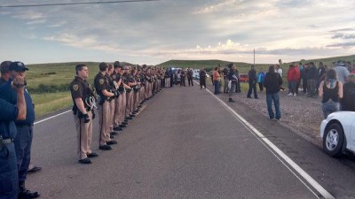
To keep to its construction schedule, the pipeline company, Energy Transfer Partners, has met nonviolent water protectors with private security guards using attack dogs in a scene reminiscent of 1963 Birmingham. It has worked hand-in-glove with law enforcement and the National Guard to create a militarized response straight out of apartheid South Africa or occupied Ireland. It has locked up hundreds of protesters in wire cages like those used early on at Guantanamo Bay. Those on the ground fear something like another Kent State, yet they keep coming, and the worldwide solidarity has gone viral.
Water protectors approach a line of riot police and armored vehicles on October 15, Carl Sack Yet for all that, when I went out to camp with the water protectors at Oceti Sakowin on October 13, I had to rely on a friend’s hand-drawn sketch posted to Facebook for directions to the camp. If you Google “NoDAPL map,” you’ll find few maps available to provide visual context for the unfolding drama. The most popular seems to be the company’s own very-small-scale route map, showing a dotted line over highlighted counties on a generic road map backdrop. Dakota Access Pipeline Route Map by Energy Transfer Partners, ENERGY TRANSFER PARTNERS, L.P. This kind of view erases the people affected by the pipeline – quite literally, by covering over their communities with a hot pink gradient fill. It doesn’t tell you that all of Turtle Island (North America) is Indian Country, or that the project runs headlong into international treaties signed between the U.S. and various tribes and then unilaterally violated by Congress. It doesn’t show you where the frontline communities have set up camp to fight back (and here I realize that I should also make a map of the Bold Iowa resistance camp), or where the pipeline company, spurred on by the internal pressure of their $3.8 billion investment, has bulldozed sacred ground, or where exactly a pipeline break would endanger the drinking water of millions downstream.

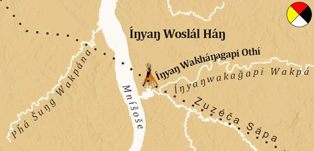
Dakota Access Pipeline Indigenous Protest Map by Jordan Engle with assistance from Dakota Wind, THE DECOLONIAL ATLAS
Maps like this are great, and there should be more of them. However, I felt strongly that there still needed to be a map of the area that would look familiar to most viewers and orient them to the important geographic facts of the struggle. I don’t claim that none of those facts are currently in dispute, but I recognize that all maps (even road maps overlaid with pink polygons) take a position and create knowledge based on the cartographer’s point of view. Maps have great power, and it’s a power anyone with pen and paper or a computer can wield.