Japan’s Volcanic Hazards as Components of Complex Systems: Nuclear Power Plants in Japan are Threatened


The past year or so has been a time of particularly vigorous volcanic activity in Japan, or at least activity that has intruded into public awareness. Perhaps most dramatic was the deadly eruption of Mt. Ontake on September 27, 2014, whose 57 fatalities were the first volcano-related deaths in Japan since 1991. On May 29, 2015, Mt. Shindake, off the southern tip of Kyushu, erupted violently, forcing the evacuation of the island of Kuchinoerabu.
That same day, Sakurajima, located just north in Kagoshima Bay, erupted more forcefully than usual. Sakurajima has been erupting in some fashion almost continuously since 1955, but since 2006, its activity has become relatively more vigorous. Indeed, a May 30 Asahi shinbun article characterized these eruptions as “the latest ominous sign that the Earth’s crust around the archipelago is getting restless.” The article argued that the twentieth century was an anomaly in that volcanic activity throughout Japan was relatively subdued, whereas the more vigorous activity of recent years is closer to the long-term normal pattern.1
Warnings of an impending eruption of the long-dormant Mt. Fuji have been common throughout the years of the twenty-first century. After the March 11, 2011 disaster (hereafter “3/11”), the frequency of hypothesized imminent eruptions of Mt. Fuji increased. For example, retired professor Kimura Masaaki, known for making grandiose predictions about earthquakes and volcanic eruptions, published books on Mt. Fuji’s eruption (already underway according to Kimura’s claims) in 2011 and 2112.2 Especially influential was a short July 2014 article in the journal Science. This study of perturbations of the earth’s crust suggested Mt. Fuji is more likely to erupt owing to effects from the 2011 Tōhoku earthquake.3 Well publicized by a press release on the eve of its publication, mass media around the world have reported this finding, along with speculation regarding possible connections between earthquakes and volcanic eruptions.
As of June 30, 2015, the Japan Meteorological Agency (JMA) designated ten volcanoes in or near the main Japanese islands as warranting levels of warning ranging from Mt. Shindake’s Level 5 (“Evacuate”), to Level 2 (“Do not approach the crater”) in seven cases. Sakurajima is at Level 3 (“Do not approach the volcano”), as is Hakoneyama, located near Mt. Fuji. Despite often-sensational reports about Mt. Fuji, it is not currently on the JMA volcanic warning list.4
The aftermath of 3/11 awakened many in Japan and around the world to the dangers of seismicity and nuclear power. Even if the magma beneath the Japanese islands had not been so active in recent months and years, it is inevitable that volcanic hazards would also enter the public discourse on nuclear power and natural disaster preparedness. Nuclear power, of course, generates an ideological opposition that runs deeper than any specific safety claims. Paul Lorenzini, argues that this ideological opposition to nuclear power is a manifestation of mistrust of modern institutions and mistrust of “the values of modern Western society that these institutions embody, particularly their capitalist economics and their reliance on science and technology.”5 In this view, failures by relevant state institutions to predict and substantially mitigate deadly or destructive natural hazards can serve as evidence that the state cannot be trusted to safeguard nuclear power. Because they are serious natural hazards, it is possible to link events like the unpredicted eruption of Mt. Ontake and anticipated events like the eruption of Mt. Fuji to the Fukushima disaster and to nuclear power.6
A 2013 Mainichi shinbun survey of volcanologists regarding volcanic hazards and nuclear power plants asked which plants are at risk. The experts mentioned the Sendai plant in Kagoshima Prefecture most often. Of the 50 survey respondents, 29 specified that the Sendai plant was at risk and 19 were opposed to its restarting. By contrast, six respondents mentioned Hamaoka in Shizuoka Prefecture, the closest plant to Mt. Fuji (and to Hakoneyama), as being at volcanic risk and two opposed its reopening. One other significant point about this survey of experts is that 12 of the 50 did not list any plants, and nine specifically stated that no plants were at risk. Based on this survey, a majority of expert opinion puts volcanism in southern Kyushu high on the list of risk to nuclear plants, but a significant number of experts do not regard volcanic hazards as a serious threat to nuclear power plants at all.7 English-language media widely reported select results of the survey.8
According to another recent assessment (circa 2009),
“virtually all operating nuclear power plants in Japan are potentially threatened by the possible harmful impacts of tephra fallout, channelized distal lava or mudflows, or tsunami. The phenomena may easily impact sites tens of kilometers or even hundreds of kilometers from the erupting volcano.”9
In addition to manifesting itself as a range of physical hazards and possibly disrupting electrical and cooling systems, volcanic ash “might transport radionuclides, either as particles incorporated into tephra fragments or as compounds absorbed into the surfaces of ash.”10 I explain these volcanic hazards in a later section.
For many, the simple fact that Japan is vulnerable to a range of natural hazards such as earthquakes, tsunamis, volcanic eruptions, and typhoons is sufficient to argue against nuclear power. However, looking at the matter in a more focused manner, linking the hypothesized near-term eruption of Mt. Fuji with a nuclear disaster requires a considerable stretch of the imagination. To be sure, a major eruption of Mt. Fuji would probably cause considerable social and economic dislocation, and it might be deadly. Moreover, the Hamaoka nuclear plant is at great risk for seismic and tsunami damage, particularly if the great Tōkai earthquake and tsunami, which many Japanese have feared as imminent since the 1970s, does in fact happen more or less as imagined. Mt. Fuji, however, is less likely to pose a serious nuclear risk. In Kyushu, on the other hand, the proximity of Kagoshima’s Sendai Nuclear Power Plant to Sakurajima and other active volcanoes that are part of the Aira Caldera (a vast pool of magma) almost certainly does constitute a major nuclear risk as well as a risk for other forms of damage to the entire region of southern Kyushu. Indeed, most of the articles in the scientific or popular press linking volcanism in Japan to nuclear hazards sensibly focus on Sakurajima and the Aira Caldera.11
While acknowledging the importance of volcanism as a hazard to nuclear power, it is not the aim of this article to discuss this topic in detail. Similarly, it is not my goal here to make predictions or to assess risk. Instead, I advance the argument that volcanic hazards interacting with human societies results in a complex system. Here I use “complex” system in a technical sense, which I explain in the final section. If indeed, volcanic hazards interacting with society constitute a complex system, then the only way to mitigate these hazards effectively is to use complex systems theory. In short, I introduce complex systems theory in the context of volcanic hazards in Japan.
With this argument in mind, this article has two main goals. First, rather conventionally, I explain the basics of volcanism and survey the range of typical volcanic hazards. In addition simply to conveying information, this survey of volcanoes is intended to suggest the wide range of variables at play in the realm of geology alone. With that background in place, I make the case that volcanic hazards are part of a complex system. Finally, I briefly explain complex systems theory, and I propose a general approach to modeling the volcanic hazard-plus-society system. One point of the whole discussion is to introduce a way of thinking about volcanic hazards that is likely to be unfamiliar to many readers. The geographical focus is Japan and the particular natural hazard is volcanism, but many of the points here are applicable to other societies and to other types of natural hazards.
Volcanoes and Volcanism
Beneath its usually calm surface, the earth is a living planet. It consists of several distinct layers defined by their composition. From the innermost layer of the earth moving outward is the inner core, the outer core, the mantle, and finally, the crust. Although the entire mantle is similar in composition, it is subdivided into two zones based on its physical properties. The upper part of the mantle is rigid, like the crust, and the upper mantle and crust together constitute the lithosphere. The interior part of the mantle, although not liquid, is softer and ductile (flexible). This ductile zone is the asthenosphere. The earth’s surface consists of a patchwork of tectonic plates. Except in certain zones where plate collisions peel away the crust from the upper mantle, tectonic plates consist of rigid crust attached to the rigid outer layer of the mantle.
The living earth moves in a variety of ways, and this movement requires heat. According to recent studies, approximately half of the earth’s heat comes from nuclear fission from radioactive elements within the asthenosphere and deeper.12 In the future, we might develop better ways of exploiting this natural nuclear energy.

Figure 1. Structure of the earth.
(“Earth poster” by Kelvinsong – Own work. Licensed under Creative Commons Attribution-Share Alike 3.0 via Wikimedia Commons).
In addition to heat from radioactivity, heat from the molten iron outer core of the earth helps warm the mantle. The heat from the core passes through the mantle, which effectively transfers this heat toward the surface via convection currents in the asthenosphere. These convection currents probably contribute to tectonic plate movement, although details of the mechanism remain speculative. Combined with plate movements, mantle convection enables the surface of the earth to radiate approximately as much heat as it receives from the nuclear reactions within it. Moreover, convection also moderates temperatures in the mantle, keeping them low enough to prevent widespread melting. However, localized melting does occur. This localized melting produces the molten rock—called magma when it is below the surface and lava when it is above—which sometimes erupts through openings in the surface known as volcanoes.
The basic definition of a volcano is simply any place where magma has reached the surface of the earth at any point in the past. It is important to bear in mind, therefore, that volcanoes occur in a wide range of types and geologic circumstances.
It is worth noting that the geothermal heat that creates volcanoes also constitutes a vast, and largely untapped, source of energy. Iceland produces approximately 30% of its electricity from geothermal energy (Japan, less than 1%).
Lava, gas, and other products of volcanic eruptions have created approximately 80% of the earth’s surface and much of its atmosphere. Today there are over 1500 active volcanoes around the world. There are several ways of classifying volcanoes, but even volcanoes in the same category vary widely regarding the details of their activity and their potential to create natural hazards. Most active volcanoes are located at the boundaries of tectonic plates. However, approximately 100 “hot spots,” roughly 15 of which are active, exist in apparently random locations, often in the stable interior of plates. For reasons not entirely understood, hot plumes of molten rock rise through the mantle to create most of these hot spots. In many cases, the molten rock does not quite reach the surface, resulting in undersea volcanic islands known as seamounts. Sometimes hot spots produce volcanic islands such as the Hawaiian Islands. The string of Hawaiian Islands and seamounts traces the movement of the Pacific Plate across a hot spot over the course of roughly 70 million years.
Volcanoes in the Hawaiian Islands are typical of those created by hot spots. The magma is relatively basaltic, which for our purposes means that it is of low viscosity. The low viscosity enables dissolved gas to escape ahead of the magma. Therefore, eruptions of Hawaiian volcanoes and most others formed by basaltic magma are rarely explosive, except when magma meets groundwater. Two well-known hot spots are exceptions to the general rule of gentle eruptions. The magma under Yellowstone National Park in the United States is a silica-rich granitic magma called rhyolite, with the potential for causing an explosive eruption that would be a worldwide catastrophe. The hot spot under Iceland exists near plate margins, and the eruptions of its volcanoes tend to be relatively explosive.
Volcanoes formed at the edges of subduction zones, however, are usually the creations of relatively andesitic magmas. Andesitic magma is more viscous (thicker) than basaltic magma and usually contains a relatively high volume of gas. Most volcanoes in Japan ore of this type. Eruptions of these volcanoes tend to be infrequent and explosive, emitting large quantities of volcanic ash when they do erupt. The 1980 eruption of Mt. St. Helens and the 1991 eruption of Mt. Pinatubo are examples of explosive volcanic eruptions. Sakurajima is a complex case because it is apparently fed by two magma chambers, one basaltic and one andesitic. Owing to changes in the underlying geology, Sakurajima’s magma mixture is becoming more andesitic.13
Even setting aside the human built environment, there is wide variability in the real or potential degree of hazard volcanoes pose. Dissolved gas is perhaps the most important variable. Water vapor is the most common gas associated with magma, with carbon dioxide, sulfur, chlorine, fluorine making up most of the rest. Taken together, these gasses are called “volatiles.” An eruption will generally be more explosive and hazardous when the viscosity of the lava is too high to allow volatiles to escape gently or if the volume of dissolved gas is extremely high. The gas tends to propel lava into the air in the form of small to medium pieces of rock commonly called “bombs” and, especially, as volcanic ash.
Strictly speaking, volcanic “ash” is not really ash because it is not the product of combustion. Volcanic ash is fine shards of magma ejected into the air, and its physical characteristics are quite different from the ordinary ash produced by fire. If, for example, you happen to be driving an automobile through the aftermath of an eruption and the windshield becomes covered with volcanic ash, do not turn on the wipers. Doing so would be like scraping abrasive sandpaper across the windshield. Volcanic ash in various manifestations constitutes a major natural hazard, as I will explain in detail.
We have seen that volcanoes occur most commonly at or near the boundaries of tectonic plates. Generally, volcanoes at the boundaries of diverging plates—undersea volcanoes at ocean ridges, for example—produce basaltic magmas, low in volatiles, that erupt effusively, not explosively. Our concern is not with volcanoes at diverging plate boundaries but with volcanoes in subduction zones.
A subduction zone is the area near the boundaries of converging tectonic plates. Oceanic crust is thinner and denser than continental crust. Therefore, plates whose leading edge is oceanic crust will subduct (push underneath) the edge of a plate consisting of continental crust. Japan is at the junction of four tectonic plates, and nearly the entire Pacific side of the country is subject to the geological processes and hazards associated with subduction zones. Earthquakes and tsunamis caused by sudden slippage of the subducting plate are the most common such hazard, and explosive volcanic eruptions are another.

Figure 2. Plate tectonics and volcanism.
(“Tectonic plate boundaries” by Jose F. Vigil. USGS – [1]. Licensed under Public domain via Wikimedia Commons)
In the case of Japan, the Nankai Trough extends offshore from Kyushu northward to near the Bōsō Peninsula. This trough is the result of the Philippine Sea Plate pushing under the Eurasian Plate. The Pacific Plate pushing under the North American Plate creates the Japan Trench, whose movement caused the 2011 Tōhoku earthquake. Although particularly known for their ability to generate megathrust earthquakes and destructive tsunamis, these subduction zones have also created Japan’s many volcanoes.
Seismicity and Volcanism
Volcanic activity coincides with earthquakes in many parts of the earth, including Japan. Moreover, the same basic geologic activity, subduction of tectonic plates, is the source of both seismicity and the volcanism in the relevant regions. It is common to assume, therefore, that some causal relationship must obtain between seismicity and volcanism. Indeed, most of the discourse since 2011 on Mt. Fuji’s impending eruption hypothesizes that the Tōhoku earthquake has played a role in making the volcano more dangerous. Nevertheless, as of now there is no widely accepted, comprehensive theory of the relationship between seismicity and volcanism.
One basic classification of earthquake types is tectonic versus non-tectonic earthquakes. Tectonic earthquakes are the result of accumulated strain in crustal rock causing a fault plane to fracture. In rare cases in which the fault surface contains no irregularities, thus keeping friction low and allowing smooth sliding, the movement of the earth is aseismic. The vast majority of fault plane ruptures, however, are seismic. In other words, accumulated strain overcomes friction, sending shock waves (seismic waves) through the earth. Tectonic, seismic earthquakes are what we typically call “earthquakes.” They range from events so minor as to be imperceptible except by the most sensitive instruments to magnitude 9 class events such as the 2011 Tōhoku earthquake, so powerful that it slightly shifted the earth’s axis.
Non-tectonic earthquakes also occur. Examples include shock waves from an underground nuclear blast or shock waves created when rock shifts because of changes in the subterranean environment. Fracking (hydraulic fracturing)-induced earthquakes are one example, as is shaking of the ground caused by the movement of magma. We can call the latter volcanogenic earthquakes. As a whole, volcanogenic earthquakes (and other non-tectonic earthquakes) tend to be less powerful than tectonic earthquakes and do not constitute a major natural hazard. As we will see, however, volcanogenic tsunamis can be a major natural hazard.
The dominant theory of earthquakes in Japan from approximately the seventeenth century into the modern era was that accumulations of warm or hot (yang) energy within the earth caused shaking by exerting upward pressure. This view easily linked both seismicity and volcanism via a single causal mechanism, a link reinforced by the proximity of volcanic eruptions and earthquakes. This understanding of earthquakes as explosive events caused by accumulated pressure within the earth persisted well into the twentieth century. One effect was to perpetuate the belief that seismicity and volcanism must be closely connected.
A typical example is a 1915 article that appeared in the Yomiuri shinbun. The article’s content derived from a presentation by the seismologist Imamura Akitsune (1870-1948). It affirmed the popular lore claiming major earthquakes occur in approximate 60-year intervals, based on the old zodiac cycle. A statistical analysis of past earthquakes, Imamura pointed out, indicates that there was some basis to the idea. Moreover, major volcanic eruptions tend also to follow a sixty-year cycle. As was common at the time, the article posited a direct link between the two geological processes. It claimed that insofar as each phenomenon releases energy, volcanic activity keeps earthquakes mild and vice-versa. The relative prominence of each type of geological activity alternates, thus producing something more like a 120-year cycle.14
Similarly, observers of Japanese earthquakes often reported balls of fire or other forms of fire, heat, or light emerging from the earth either just before or during an earthquake. For example, in an official report on the Great Kantō Earthquake of 1923, meteorologist Fujiwara [Fujiwhara] Sakuhei (1884-1950) reported at length on a great ball of fire rising into the air at a 15-degree angle from the Nikolai (Holy Resurrection) Church in Surugadai.15 The details need not concern us, but such sightings were conceptually possible in part because of the assumption of a close link between seismicity and volcanism. As knowledge of both phenomena increased dramatically during the 1960s, many specialists no longer regarded volcanism and seismicity as directly linked to each other, but rather as the results of a geology based on tectonic plates and their movements.
In a book for general audiences, seismologist Shimamura Hideki titled one short chapter with the question, “Is there a connection between the activity of volcanoes and earthquakes?” His reply begins, “Earthquakes and volcanoes are both phenomena originating under the earth’s surface, so there must be some kind of connection between them, but unfortunately contemporary science is not able to say what that is.” He then discusses several examples of eruptions occurring soon after earthquakes. In 1707, Mt. Fuji erupted 49 days after the massive (estimated M8.4) Hōei earthquake. Nine months after the 1604 Keichō earthquake, Hachijōjima erupted. Shimamura concludes that it is “not strange” that earthquakes might trigger eruptions and vice versa.16
In a textbook, volcanologist David Rothery explains similarly, distinguishing between tectonic and volcanogenic earthquakes:
Apart from occasionally, triggering an eruption there is no straightforward link between [tectonic earthquakes] and volcanism. A tectonic earthquake may set off an eruption that would have happened eventually anyway, but is not going to create a new volcano or produce a magma supply where none previously existed. In marked contrast, volcanogenic earthquakes are consequences, rather than causes, of eruptions and of the magma movements leading up to eruptions. They are not so powerful as tectonic earthquakes and can usually only be felt (if at all) only close to the volcano.17
The assessments of Shimamura and Rothery agree that there is no known mechanism directly linking seismicity and volcanism.
Magma can rise to the surface only if it is less dense than the surrounding solid rock, and density is therefore the most important factor in the buoyancy of magma. Other conditions that control the flow of magma include the precise composition, which often changes as magma moves, viscosity, and the physical structure and characteristics of the rocky conduits through which magma moves or in which it collects. Whether, when, and in which manner a volcano erupts is a function of the local details of each volcano. Often chambers of magma exist in a delicate balance such that a small change in relevant parameters might allow magma to come to the surface or prevent it from doing so. It is with respect to his point that the seismic waves of tectonic earthquakes might alter significantly the local details of a particular volcano, typically by changing the physical conditions of a volcano’s internal “plumbing.” Currently, it is not possible to make general statements about the effects of seismic waves on volcanic structures, nor is it possible in individual cases to predict changes in future volcanic activity owing to the possible influence of seismic waves. The key point for our purposes is that although both the seismicity and the volcanism affecting Japan are byproducts of plate tectonics, they are best regarded as separate phenomena.
VEI and other Volcanic Metrics
As with earthquakes, specialists have developed metrics for some of the major characteristics of volcanic eruptions. To some degree, these metrics are related to the potential destructiveness of an eruption, that is, of its severity as a natural hazard. The extent to which this potential will actually manifest itself as a natural disaster, however, is an emergent phenomenon not directly predictable from the simple behavior of individual elements in the natural-social matrix. In other words, the process whereby a natural hazard intersects with human society, especially, but not limited to the built environment, constitutes a complex system in the technical sense (as opposed simply to being complicated). I will return to this point in the final section.
In the case of volcanoes, explosive eruptions are particularly hazardous. The Volcanic Exclusivity Index (VEI) ranges from 0 to 8. It is a function of two variables. The first is the volume of fragmented material erupted (in cubic meters), and the second is the height of the eruption column (in kilometers). Most Japanese volcanic eruptions fall within the VEI 2-4 range, releasing between 106-109 cubic meters of fragments, with eruption columns ranging from 1 kilometer to 25 kilometers in height.
The 1598 and 1783 eruptions of Mt. Asama are estimated at VEI 3 and 4 respectively, and the estimate of Mt. Fuji’s 1707 eruption is VEI 5. The 1914 eruption of Sakurajima in Kagoshima was VEI 4. The eruption of Mt. St. Helens in 1980 was VEI 5, and that of Mt. Pinatubo in 1991 was VEI 6. In 1815, a VEI 7 eruption of Tambora in Indonesia resulted in roughly 60,000 fatalities and altered worldwide climate for years. Indeed, 1816 became the “year without a summer.” There have been no VEI 8 eruptions during the past 11,700 years (the Holocene epoch), but there is strong evidence for several such eruptions during a period ranging from roughly 25 thousand-27 million years ago. Several of these VEI 8 eruptions took place in the region of today’s Yellowstone National Park. What would be the consequences of a future VEI8 eruption in Japan? It is not too much to imagine a re-boot for the whole enterprise of human and animal life on earth.
The geological history of the Japanese islands includes several VEI 7 eruptions. Volcanoes capable of producing VEI 7 or VEI 8 eruptions are commonly called “supervolcanoes.” Japan is home to three VEI 7 class supervolcanoes or volcanic calderas. One is the Kikai Caldera under the Ryukyu Islands, one is Mt. Aso in Kyushu’s Kumamoto prefecture (which erupted in late November 2014), and the third is the Aira Caldera, of which Sakurajima is a part.
It is important to emphasize that the VEI scale does not say anything about the actual deadliness of an eruption. For example, there were no known fatalities resulting from Mt. Fuji’s 1707 VEI 5 eruption. By contrast, the VEI 0 lava dome collapse of Mt. Unzen in 1792 resulted in approximately 14,300 fatalities. As with earthquakes, the deadliness of volcanic eruptions depends on the interaction of a complex array of variables.
The magnitude of a volcanic eruption is a measure of the total mass of ejected material, and the known range is from 0 to 8. In the case of explosive eruptions, eruption magnitude and VEI are similar. A third measure of eruptions is intensity, which is the peak rate at which material erupts. The highest known rating is 12, corresponding to one billion kg/second of erupted material. These measurements can be useful for certain types of classification. However, in assessing the degree of danger a particular volcano may pose, it is necessary to consider a range of possible volcanic hazards as they are likely to play out in local conditions. The following section is a survey of the most common types of volcanic hazards relevant to Japan and many other subduction zone areas such as the Pacific Northwest of the United States.
Volcanic Hazards: Lava, Pyroclastic Flows, Debris Avalanches, Lahars, Ash, Tsunamis
The first volcanic hazard that probably comes to mind for many is lava flows. Lava usually flows so slowly, however, that it is the least deadly of the volcanic hazards. Moreover, flowing lava is more typical of the basaltic lavas of Hawaiian-style eruptions, not the explosive eruptions common in Japan and other subduction zones.
Explosive eruptions can produce pyroclastic flows. Sometimes called an ash flow, a pyroclastic flow consists of a mass of various ejected debris that behaves like a liquid moving rapidly. Often a rapidly moving cloud of gas and debris (called nuée artente) accompanies a pyroclastic flow. These flows can be extremely lethal. In 1902, for example, Mt. Pelée on the French Caribbean island of Martinique erupted. On the morning of May 8, a pyroclastic flow traveled the 6 kilometers from the volcano to the town of St. Pierre, and wiped it out, killing all but one of its 28,000 residents and even capsizing or de-masting ships in the harbor. Pyroclastic flows have accompanied many eruptions of Japanese volcanoes such as Mt. Fuji in 1707, Mt. Asama in 1783, and Mt. Unzen between 1990 and 1996. The collapse of a magma dome is a common cause of pyroclastic flows. Some pyroclastic flows (pyroclastic density currents) contain sufficient energy to flow over topographic barriers that might be expected to contain or stop most currents of material.
In 1792, Mt. Unzen killed over 14,000 people, but not because it erupted. Instead, the collapse of an old lava dome generated a debris avalanche, and this cascade of falling debris accounted for most of the fatalities. A debris avalanche also killed about 400 in connection with the 1888 eruption of Mt. Bandai in Fukushima Prefecture. Large quantities of debris often accumulate on the sides of volcanoes, and they constitute a potentially severe hazard when populated areas are within range of a possible avalanche. Heavy rain or other non-eruption events can trigger debris avalanches, and it is possible in some cases that the disruptions caused by an avalanche could trigger an eruption.
A third type of dangerous flow is a lahar, a volcanic mudflow, which usually follows topographic channels. The mud in this case is mainly ash mixed with water, but other materials can contribute to the slurry. A common scenario is that the eruption melts a volcano’s ice cap. Lahars are deadly. They travel fast and far, and require as little as 10% water to remain mobile. As a lahar travels through a valley or other channel, it picks up additional material. In this way, some lahars have the potential to do great damage a long distance from the site of an eruption, particularly if they burst out of the confines of a valley. In 1985, for example, a lahar in Colombia from the Nevado Del Ruiz volcano wiped out the town of Armero, which was 65 kilometers distant. Over 23,000 of Armero’s residents perished. Another key feature of this tragedy was that the eruption itself was not particularly large or severe. The presence of a large ice cap on the volcano and the location of Armero in a river valley that passed near the volcano were the main factors in this case. Lahars entering rivers can cause massive flooding and thus potentially endanger facilities located near rivers, even when far from an active volcano.
Changes in the built environment can also be significant insofar as they change topography. For example, the City of Seattle website points out that there is no evidence of a lahar from Mt. Rainier reaching the present location of the city during the past 10,000 years. Nevertheless, in light of modern development of the region, it is impossible to say that Seattle is now out of range.18 Because any type of volcanic flow plays out according to local topography, historical data can only serve as a rough guide for future possibilities in developed countries.
Heavy rain can liquefy deposits of unconsolidated volcanic ash and cause a lahar. In some circumstances, these rain-induced lahars can persist for years. In 1998, a hurricane-induced lahar in Nicaragua entirely wiped out two small towns. Japanese volcanoes are subject to Lahars. One relatively recent example is Mt. Unzen. This video shows footage from three different lahars in Japan, beginning with Mt. Unzen in 1993:
Notice that volcanic ash (often called tephra) plays a major role in the volcanic hazards described thus far. Insofar as it enriches soil, volcanic ash can be beneficial. In many other respects, however, volcanic ash is a serious hazard. Depending on circumstances, ash can travel far from its point of origin. Precipitating onto the ground, ash can damage plant and animal life and thereby alter the natural or agricultural environment. Suspended in the air, ash can effect climate. More acutely, clouds of volcanic ash are a threat to aviation. The ash clouds look like ordinary atmospheric vapor clouds and are difficult to detect. The abrasive ash damages turbine engines, often turning to glass inside them and shutting them down. Over 100 encounters between aircraft and volcanic ash have taken place, some of which resulted in the shutdown of all engines. Despite some very narrow escapes, all such flights ended with successful emergency landings after some of the engines were re-started. When pilots realize they are in a volcanic ash cloud, the basic procedure is to cut back on the engines and glide out of the cloud. The rush of cold air makes the ash-turned-to-glass become brittle and shatter, thus allowing the engines to re-start. The spring 2010 eruption of the Icelandic Eyjafjallajökull disrupted air traffic for months.
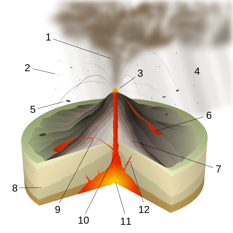
Figure 3. Diagram of a Vulcanian eruption. Key: 1. Ash plume 2. Lapilli 3. Lava fountain 4. Volcanic ash rain 5. Volcanic bomb 6. Lava flow 7. Layers of lava and ash 8. Stratum 9. Sill 10. Magma conduit 11. Magma chamber 12. Dike. (“Vulcanian Eruption-numbers” by Sémhur (talk) – Own work, from the document about volcanism on the Portail sur la prévention des risques majeurs (web portal about the prevention of the major risks) of the Ministère français de l’Ecologie, du Développement et de l’Aménagement durables (French Minister of the Ecology, Environment and Sustainable Development). Licensed under Creative Commons Attribution-Share Alike 3.0-2.5-2.0-1.0 via Wikimedia Commons) |
Volcanoes can erupt underwater. Moreover, volcanically induced debris avalanches, landslides, or pyroclastic flows have the potential, in some circumstances, to displace enough water to generate tsunamis as destructive as those generated by megathrust (subduction zone) earthquakes. The 1883 VEI 6 eruption of Krakatau in Indonesia generated tsunami waves that killed over 30,000 along the coasts of Indonesia and Sumatra. Volcanoes and the areas around them are often unstable, as we have seen in the example of rain-induced lahars. Therefore, an eruption is not necessary. The 1792 collapse of the old lava dome in Mt. Unzen generated a tsunami that killed nearly 15,000.
Volcanic Hazards as Part of a Complex System
Throughout the current century, Mt. Fuji has been on the verge of erupting, according to mass media articles, some scientific papers, and the blogosphere. Particularly in light of Japan’s recent experiences with natural disasters, such reports about Mt. Fuji often feature a sensational tone.19 Although some types of volcanic eruptions can be predicted fairly well in the short term, after classic signs of magma movement begin, there is no way to know when Mt. Fuji will begin to manifest measurable signs of an eruption. The event could begin tomorrow, or it could happen centuries from now. In this sense, volcanic eruptions are as unpredictable as earthquakes.20 Similarly, given the vast differences in the physical and social topography compared with 1707, the historical record of that earlier eruption is of little use in planning for the present and future. That past event does underscore the near certainty of large quantities of volcanic ash blanketing the Tokyo metropolitan area. Although unlikely to be a direct cause of many fatalities, a major eruption of Mt. Fuji would likely be severely disruptive. Major transportation hubs would likely shut down, and large portions of modern infrastructure would be subject to damage or destruction from ashfall.
Is Japan as a whole and the Tokyo region in particular ready and able significantly to mitigate the damaging effects of a major eruption of Mt. Fuji were it to happen tomorrow? I am not in a position to say with any certainty. Most likely, variables such as warning period (if any) preceding the eruption, size, duration, and other parameters of the eruption, wind patterns, the robustness of key elements of infrastructure, the nature of political and administrative responses, and many other factors will interact to produce an outcome that is nearly impossible to predict. This outcome will emerge from the interaction of these many parameters, variables and social and natural agents. In other words, an event such as a major eruption of Mt. Fuji within the broader context contemporary Japanese society, unfolding over time, constitutes a complex system. Complex systems theory, a rapidly developing field, seeks to understand—and possibly to influence—such systems.
The roots of complex systems theory extend to a seminal 1948 paper by Warren Weaver, who wrote of a “middle region” of “organized complexity” in between the simple two-variable problems common before 1900 and the unlimited-variable probability based problems of the early twentieth century such as thermodynamic laws, actuarial tables, or anticipating traffic along phone networks.21 Warren’s paper laid out the general intellectual agenda, and advances in computing power provided the means for the emergence and development of the interdisciplinary field of complex systems theory in the 1970s.
There are several different categories of complex systems. Because the field of complex systems theory is so new, there tends to be some overlap between these categories. Natural hazards interacting with human societies constitute a multi-agent system (MAS). Numerous interacting elements, usually called “agents,” comprise such a system. Some agents are passive (no goals, no volition), others are active in a simple manner (e.g., an instinct in an animal), and others are active in a complex manner (e.g., human motives). The interaction of any subset of agents typically affects the system as a whole in ways that are often difficult to predict. In this sense, phenomena “emerge” from such systems. Emergent phenomena are a classic indicator of complex systems. It may also be possible to classify complex systems created by the interaction of natural hazards and human societies as complex adaptive systems (CAS), examples of which include, the immune system, and ecosystems. The key point for our purposes is that whether regarded as an MAS or CAS, an important tool for comprehending the behavior of natural hazards interacting with societies is agent-based modeling.
Simply stated, agent-based modeling attempts to gain insights into the behavior of complex systems, especially the impact of specific agents (or variables such as population density) on the system as a whole. Such modeling seeks to identify the relevant agents and assign behavior rules to them. Agent-based modeling typically takes into consideration the broader environment, issues of scale (often called “granularity”), adaptation or learning rules, and, in the case of active agents, decision-making heuristics. Such modeling seeks to understand the big picture, as opposed to solving narrowly focused pragmatic problems common in fields such as engineering. A better (though typically never complete) understanding of the big picture can be useful in allocating resources, creating contingency plans, and formulating policy. In the case of volcanism and other natural hazards, effective modeling might permit better insight into how the behavior of key agents would play out in different scenarios. After a model is created, it can be run on computers repeatedly. Such repetition can permit the application of the usual statistical metrics. Moreover, once the model is set up in software, it becomes possible easily to modify the behavior of any key agent or variable and re-run the simulation. New experimental or observational data can be used to tune the model.
There are many shortcomings of agent-based modeling, and I do not intend to present it as a panacea. Even the most sophisticated models fall short, often far short, of simulating the complexities of the real world. Not only is it often impossible to include all the relevant agents in a model, but the behavior rules assigned to agents are typically very simple. Moreover, creating truly useful models would require considerable time, resources, and, mostly likely, extensive collaboration between academic, industry, and government entities. Any insights tentatively gained from sophisticated modeling efforts would need to be compared with real-world data in an effort better to tune the models. In short, a serious effort to construct useful agent-based modeling for natural disaster scenarios would be a large-scale endeavor, it would likely take years to come to any fruition, its results would be imperfect, and insights gained from modeling would require careful translation into plain language and key points for use in most political and administrative settings.
I should also point out that government agencies and industries frequently employ other kinds of models to deal with smaller sets of variables and to solve specific problems.22 Modeling is hardly new, but agent-based modeling of natural hazards and disasters has been minimal. Although not exhaustive, my own searches have turned up only a few narrowly focused models. The demands of academic publishing tend to mitigate against bold, big-picture projects, and what I have proposed here is certainly ambitious for many reasons. Despite the imperfect nature of even the most sophisticated models, they are the only tool we presently have to understand complex systems and thus develop better strategies for dealing with them.
To illustrate this modeling process, let us return to Mt. Fuji. Suppose we were to create an agent-based model for a major eruption in 2015. To keep this illustration manageable, let us focus only on one hazard: volcanic ash. Moreover, as this hazard plays out over time, my illustration includes only a subset of the possible agent interactions. For the purposes of modeling, we would need to identify the relevant variables, agents, and impacts. It would be necessary to assign initial values and to specify rules of interaction among the agents. How would we even begin? Fortunately, the scientific and engineering literature provides good starting points with respect to interactions between any two agents. For our example of volcanic ash, the article “Volcanic ash impacts on critical infrastructure” by Thomas M. Wilson and colleagues is especially helpful.23 My illustration here focusses on a subset of those hazards.
Shown here is a portion of a possible agent-based model for an eruption of Mt. Fuji. Bear in mind that the processes illustrated here would play out over time, and the model would produce different results for different time intervals. Let us begin with the blue boxes to the left. They indicate the major variables that constitute the quantity, quality, and distribution of ash. Wind speed and direction, other weather conditions, the quantity of ash erupted, the length of time of the eruption, distance from the cone, and other variables (e.g., height of the ejected ash) create what I call an “ashfall topography.” Initial values for these variables might be those of the 1707 eruption, insofar as they are known, supplemented with data from other eruptions of similar volcanoes elsewhere. Consider the “Other weather” variable briefly. Volcanic ash has a different effect on components of the electric power grid depending on whether it is dry or damp. A light rain, for example, might create a paste that causes a phenomenon known as flashover (see the Wilson article for details), but a heavy rain might wash ash out of places where it might otherwise cause problems. Notice that differences in random variables and starting conditions can result in significantly different impacts, a classic sign of a complex system.
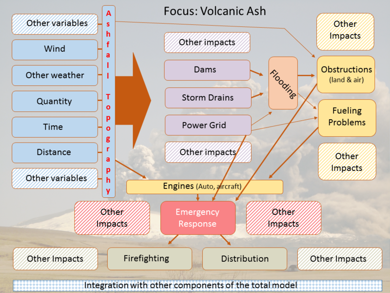
|
Ashfall topography is an emergent phenomenon that derives from the interaction of a cluster of variables. Consider next the first round of impacts in the center, only a few of which are listed here. Most of Japan’s rivers are dammed, and ashfall might affect dams in various ways (e.g., altering water flow, water levels, interfering with the physical operation of dams), some of which might lead to flooding or adversely affect the power grid. Similarly, large quantities of volcanic ash often forms rock-like clogs in ware runoff and storm drain systems, thus resulting in flooding. Parts of the electric power grid are susceptible to ash damage, and power outages, or a complete shutdown, might exacerbate flooding, cause other infrastructure problems such as shutting down fueling systems, and directly interfering with emergency response. Ashfall itself contributes to physical obstruction of roadways, bridges, and airspace. Flooding, too, would likely contribute to land obstructions and alter the ash topography (and vice versa). Volcanic ash damages auto and aircraft engines. All of these impacts would adversely affect emergency responses such as firefighting or the distribution of essential food and medicine. Other impacts might include a deterioration of sanitary conditions, leading to the spread of disease, strains on medical infrastructure, and more.
Not fully shown in the diagram are the feedback loops and interactions between these various agents whereby both adapt to each other, thus altering the system as a whole, which in terns cases more of its agents to adapt. On other words, the complex system would not play out in a linear, additive manner, but in a way such that the whole would be more than the sum of its parts and would change over time.
It should be clear from this brief illustration that creating a robust, sophisticated model for an eruption of Mt. Fuji or other natural hazards would require carefully coordinated teams of experts. Most likely, the model would need to be created in modules. After completion, such a model would need frequent tuning. After the model is reasonably well tuned, exploiting it, that is running simulations with under different sets of conditions, would likely take years. Serious resources and work on such a project might require a decade or more produce something useful. Such a model would not be able to predict the onset of volcanic eruptions or earthquakes, in part because the basic physical mechanisms for the causes of these phenomena (especially earthquakes) are not yet known with sufficient precision to create viable rules for agents. The promise of agent-based models would be the ability better to understand the interaction of volcanic or other hazards with society and to identify especially important variables or agents. Could such a model tell us how many people would likely die in an eruption of Mt. Fuji? Possibly. Perhaps more important than estimating an absolute number of fatalities, a well-designed model would likely identify currently unsuspected agents or conditions that would contribute to a relatively higher or lower incidence of fatalities. In some cases (e.g., wind direction), these agents may be entirely beyond human control, but in some cases it may be possible to alter the conditions. In any case, such knowledge would be valuable.
What about the short term? One insight from complex systems theory is a tradeoff between exploration and exploitation. Because optimal points in complex systems are rarely clear and rarely stable, additional exploration (more data collection, creating better models, running more simulations, etc.), if well done, is likely to produce useful knowledge. The opportunity cost for such exploration, however, is fewer resources devoted to exploiting whatever knowledge we currently have. Major volcanic eruptions are rare events compared with natural hazards such as typhoons, flooding, or even earthquakes. Our big picture knowledge of the way volcanic hazards are likely to play out in the complex system that is Japanese society tends to be narrowly focused. Nevertheless, there is little choice but to devote some resources to exploiting that meager knowledge—that is, to allocate resources and devise plans to mitigate likely volcanic hazards based on best estimates without the aid of powerful models. The historical record, too, if used with caution, can inform this exploitation process. My larger point, however, is to argue for—or at least suggest the possibility of—the need for more and better exploration (modeling) to set the stage for effective mitigation of volcanic and other natural hazards in the future.
Volcanic hazards are clearly a danger to many parts of Japan and elsewhere. The existence of nuclear power plants exacerbates the risks for Japan and the region. Indeed, more so than seismic hazards, volcanic hazards have the potential, in the most extreme cases, to disrupt the ecosystem of the entire earth. It makes sense, therefore, to take obvious short-term steps to prepare for likely volcanic hazards. Although these points should be obvious, the devil is in the details with respect to resource allocation and social priorities. Moreover, the complexity of contemporary society contributes to a lack of knowledge about what will actually happen in the case of a major eruption. My proposal here for a sustained effort at more sophisticated modeling offers no panacea, but it is one suggestion for dealing more effectively with this problem in the future.
Gregory Smits is an Associate Professor of History at Pennsylvania State University. He is a social and cultural historian of Japan, whose interests range from the fifteenth through the early twentieth centuries. A specialist in the history of the Ryukyu Kingdom and of the impact of earthquakes on society, he is the author of Visions of Ryukyu: Identity and Ideology in Early-Modern Thought and Politicsand co-editor with Bettina Gramlich-Oka of Economic Thought in Early-Modern Japan. He is the author of two studies of Japanese earthquakes: When the Earth Roars: Lessons From the History of Earthquakes in Japan and Seismic Japan: The Long History and Continuing Legacy of the Ansei Era Earthquakes.
Related articles
•Kyle Cleveland, Mobilizing Nuclear Bias: The Fukushima Nuclear Crisis and the Politics of Uncertainty
•Oguma Eiji, Nobody Dies in a Ghost Town: Path Dependence in Japan’s 3.11 Disaster and Reconstruction
• David McNeill and Paul Jobin, Japan’s Triple Disaster, Introduction
• Philip C. Brown,Call it A ’Wash’? Historical Perspectives on Conundrums of Technological Modernization, Flood Amelioration and Disasters in Modern Japan
• Shineha Ryuma and Tanaka Mikihito,Mind the Gap: 3.11 and the Information Vulnerable
• Yasuhito ABE, Safecast or the Production of Collective Intelligence on Radiation Risks after 3.11
• Gregory Smits, Danger in the Lowground: Historical Context for the March 11, 2011 Tōhoku Earthquake and Tsunami
• Peter Navarro, Earthquake Repercussions Spur Rethinking of China’s Dam Building Strategy
Notes
1 “Greater volcanic activity in Japan looks like the new norm,” The Asahi Shinbun, May 30, 2015.
2 For a typical example of how Kimura’s claims have been reported in the popular media, see “’Mt. Fuji Should Erupt by 2015’: Ryukyu University Professor Emeritus,” Rocket News 24, January 8, 2013.
3 Brenguier, F. Campillo, M., Takeda, T., Aoki, Y., Shapiro, N.M., Briand, X., Emoto, K., & Miyake, H., “Mapping pressurized volcanic fluids from induced crustal seismic velocity drops,” Science¸ Volume 345, Issue 6192 (July 4, 2014): 80-82. DOI: 10.1126/science.1254073.
4 See here (accessed 7-13-2015).
5 See “A Second Look at Nuclear Power,” in Issues in Science and Technology(Spring 2005).
6 See, for example, Nassrine Azimi, “Japan’s Natural Perils, and Promises, in the Wake of Fukushima,” The Asia-Pacific Journal, Vol. 12, Issue 43, No. 1, October 27, 2014, especially the first several paragraphs. For a specific linking of Mt. Fuji and the plant at Hamaoka, see Akio Matsumura, “Japan’s Fault: The Risks of Mt. Fuji’s Eruption and Nuclear Power.” July 31, 2013.
7 The original reporting includes “Genpatsu: Kazangakusha ‘kyodai funka, risuku’ Hokkaidō・Tomari nado eikyōdai—Mainichi shinbun ankeeto,” Mainichi Shinbun, December 23, 2013, Tokyo edition and “Kurōzuappu 2013: Kyodai funka, genpatsu no rinku hassei hindo hikuku, yosoku konnan okoseba ‘higai jindai,’ Mainichi Shinbun, Decenber 23, 2013, Tokyo edition.
8 To cite but one of the many examples, see “Japanese volcanologists say several nuclear power plants at risk if major eruptions happen,” Japan Daily Press,December 24, 2013.
9 C. B Connor, R. S. J. Sparks, M. Díez, A. C. M. Volentik and S. C. P. Pearson, “The Nature of Volcanism,” in Charles. B. Connor, Neil A. Chapman, and Laura J. Connor, eds., Volcanic and Tectonic Hazard Assessment for Nuclear Facilities(Cambridge University Press, 2009), 94-95.
10 Connor, et al., “The Nature of Volcanism,” 97.
11 For example, see Kazue Suzuki, “Japan’s Plan to Restart Nuke Plants Ignores Lessons Learned From Fukushima,” in Ecowatch, July 16, 2014.
12 The KamLAND Collaboration, “Partial radiogenic heat model for Earth revealed by geoneutrino measurements,” Nature Geoscience 4, 647–651 (July, 2011), doi:10.1038/ngeo1205.
13 UCL Volcano Co2 Group, “Sakurajima” accessed 715-2015).
14 “Tsūzoku jishin monogatari” (jō), Yomiuri shinbun, November 19, 1915, morning edition, 5.
15 Report quoted in Musha Kinkichi, Jishin namazu (Akashi shoten, 1995), 76-77.
16 Shimamura Hideki. Nihonjin ga shiritai jishin no gimon rokujūroku: jishin ga ōi Nihon dakara koso chishiki no sonae mo wasurezu ni (Soft Bank Creative, 2008), 90-92.
17 David Rothery, Volcanoes, earthquakes, and tsunamis (McGraw-Hill, 2007), 60.
18 “Volcano Hazards including Lahars,” (accessed 7-17-2015).
19 For example, in addition to some of the items cited previously, see David Wolman, “Mt. Fuji Overdue for an Eruption, Experts Warn,” National Geographic News, July 17, 2006; Martin Frid, “What Will You Do If Mt Fuji Erupts?”Treehugger, December 15, 2008; F. Brenguier, et. al., “Mapping pressurized volcanic fluids from induced crustal seismic velocity drops,” Science, Vol. 345, Issue 6192 (July 4, 2014), 80; Lily Kuo, “What would happen if Mount Fuji erupted for the first time in 307 years?” in Quartz, July 17, 2014; Sara Gates,“Mount Fuji Is In A ‘Critical State’ And Could Be Ready To Blow, Researchers Say,” The Huffington Post, July 17 [updated July 24], 2014; “New evacuation plan for Mount Fuji eruption calls for 1.2 million to flee,” Japan Times, February 6, 2014.
20 Major earthquakes usually happen without any warning. The earth suddenly shakes. Even in cases where there are foreshocks in the weeks, days, or hours before a main shock, there is no way to know at the time whether a relatively small earthquake is the main shock of its own event, an aftershock of some past event, or a foreshock of a future event. By contrast, a well-known set of changes usually, but not always, takes place over the course of days, weeks, or (often) months prior to the occurrence of a large eruption. Traditional monitoring methods include strategically positioned seismometers, measurements of ground deformation, and the monitoring the quantity and qualities of certain volatiles. Increases in the frequency of small earthquakes around the magma chamber(s), increased ground swelling, and increased quantity of gas emitted (as well as changes in the qualities of the gas) are all classic signs that magma is expanding. Typically, this expansion plays out over enough time for people nearby to evacuate safely.
21 Several of the many examples of middle region problems Warren proposed are: “How can one explain the behavior pattern of an organized group of persons such as a labor union, or a group of manufacturers, or a racial minority? There are clearly many factors involved here, but it is equally obvious that here also something more is needed than the mathematics of averages. With a given total of national resources that can be brought to bear, what tactics and strategy will most promptly win a war, or, better: what sacrifices of present selfish interest will most effectively contribute to a stable, decent, and peaceful world?” Warren Weaver, “Science and Complexity,” American Scientist, 36: 536-544, 1948. (reprint edition, p. 5).
22 For many examples, some specific to Japan, see Charles. B. Connor, Neil A. Chapman, and Laura J. Connor, eds., Volcanic and Tectonic Hazard Assessment for Nuclear Facilities (Cambridge University Press, 2009).
23 Wilson, T.M., et al. “Volcanic ash impacts on critical infrastructure.” J. Phys. Chem. Earth (2011), doi: