

Update: Hurricane Michael made landfall at 2 pm EDT October 10, 2018 near Mexico Beach, FL with top sustained winds of 155 mph and a central pressure of 919 mb. This makes Michael the strongest landfalling mainland U.S. hurricane (by pressure) since Camille of 1969, which had a 900 mb pressure, and the strongest by wind speed since Hurricane Andrew of 1992, which had 165 mph winds. Note that Hurricane Maria of 2017 hit Puerto Rico with winds of 155 mph and a central pressure of 920 mb, and was virtually identical in intensity to Michael.
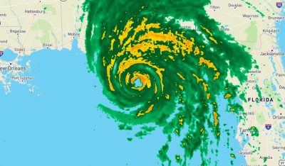
Hurricane-force wind gusts, torrential rains, and a massive storm surge are belting Florida’s Panhandle as extremely dangerous Hurricane Michael closes in on an afternoon landfall. At 1 pm EDT, the hurricane hunters found that Michael was still intensifying, with sustained winds of 150 mph and a central pressure of 919 mb. A storm surge of over eight feet was already affecting the Panhandle, inundating many escape routes. Michael is poised to be one of the most top-ten most intense hurricanes on record to make landfall in the U.S.
If you are in the hurricane’s impact zone, now is the time to hunker down in your safe shelter and not be out driving. Remember that winds are stronger the higher up you go; if you are sheltering in a high-rise building, the lower floors will be safer than the upper floors. According to the National Hurricane Center’s classification of Category 4 wind damage, this is what can be expected where the eastern eyewall of Michael comes ashore:
Catastrophic damage will occur: Well-built framed homes can sustain severe damage with loss of most of the roof structure and/or some exterior walls. Most trees will be snapped or uprooted and power poles downed. Fallen trees and power poles will isolate residential areas. Power outages will last weeks to possibly months. Most of the area will be uninhabitable for weeks or months.

Figure 1. GOES-16 visible satellite image of Hurricane Michael at 10:45 am EDT October 10, 2018. Image credit: NOAA/RAMMB.
Another bumpy flight in #HurricaneMichael. What a monster. One of the most dynamically active storms I have ever seen, with eyewall mesovortices inside a small, steep eye. pic.twitter.com/5A3atKZPrZ
— Andy Hazelton (@AndyHazelton) October 10, 2018
At 2:12 pm EDT, the storm tide at Apalachicola, FL peaked at 7.72’ above high tide (Mean Higher High Water, or MHHW), which was the highest water level on record there (going back to 1967). Hurricane Dennis of 2005 (a 6.43’ storm tide) held the previous record. The highest storm surge at the site (height of the water above the normal tide) was 8.53′. NHC predicted a storm surge of 8 – 14 feet for this portion of the coast.
At 2:06 pm EDT, the storm tide at Panama City, FL peaked at 5.31’ above MHHW, which was the second highest water level on record. The record was 5.72’ above MHHW, set on October 4, 1995 during Hurricane Opal. The highest storm surge at the site (height of the water above the normal tide) was 5.62′. Records extend back to 1973 at the site.
At 2:54 pm EDT, the storm tide at Cedar Key, FL peaked at 4.05’ above MHHW, their 6th highest water level on record.
NOAA buoy 42039, located about 90 miles (145 km) south-southwest of Panama City, Florida, reported sustained winds of 60 mph (97 km/h) and a wind gust of 76 mph (122 km/h) at 5:50 am, before the buoy stopped transmitting data. The highest significant wave heights were 30.8 feet at 4:50 am EDT.
Tyndall Air Force Base, which got the western eyewall winds of Michael, reported sustained winds of 86 mph, gusting to 129 mph, at 12:19 EDT, five minutes before the station stopped sending data. This measurement was taken at 30 meters, so is higher than the winds that would be reported from the standard 10-meter measuring height.
According to NHC, a wind gust of 130 mph was reported between 1 – 2 pm EDT at a University of Florida/Weatherflow observing site near Tyndall Air Force Base before the instrument failed. A wind gust of 129 mph (207 km/h) was reported at the Panama City Airport.

Figure 2. Table of landfalling mainland U.S. Category 4 and 5 hurricanes since 1851. Image credit: Dr. Phil Klotzbach. To convert from knots to mph, multiply by 1.15. Rounded to the nearest 5 mph, 115 knots = 130 mph, 120 knots = 140 mph, etc.
Strongest U.S. landfalling hurricane on record so late in the year
Michael made landfall more than a month later than all of the historic storms that were stronger, and is the strongest landfalling U.S. hurricane so late in the year. One good reason for this is the exceptionally warm ocean waters in the eastern Gulf of Mexico which powered Michael; Florida had its warmest September on record last month, and this helped heat up the waters of the eastern Gulf to 2 – 4°F (1 – 2°C) above average. Global warming makes record-warm Septembers like Florida experienced more likely to occur, and thus made a record-strong late-season hurricane like Michael more likely to occur.
Landfalling Category 4 hurricanes are rare in the mainland U.S., with just 24 such landfalls since 1851—an average of one every seven years. (Category 5 landfalls are rarer still, with just three on record). Only four Category 4 hurricanes have made landfall in October or later, and just two of these made landfall later than October 10: Hurricane King (October 18, 1950 in Florida), and Hurricane Hazel (October 15, 1954 near the NC/SC border). Both hit with top winds of 130 mph.
In records going back to 1851, only nine hurricanes have struck the Panhandle with Category 3 or stronger winds. The strongest were the 1882 Pensacola hurricane and 1975’s Hurricane Eloise, both of which came ashore with winds of 125 mph. Since 1900, there has been only one Category 4 or 5 landfall anywhere on the northern Gulf Coast (from Beaumont to Cedar Key): Category 5 Hurricane Camille in 1969.
Michael is the strongest landfalling mainland U.S. hurricane (by pressure) since Camille of 1969, which had a 900 mb pressure, and the strongest by wind speed since Hurricane Andrew of 1992, which had 165 mph winds. Note that Hurricane Maria of 2017 hit Puerto Rico with winds of 155 mph and a central pressure of 920 mb, and was virtually identical in intensity to Michael. According to NOAA’s Hurricane Research Division, only two landfalling mainland U.S. hurricanes have hit at a lower pressure–the 1935 Labor Day Hurricane in the Florida Keys (892 mb) and Hurricane Camille in Mississippi (900 mb), both Category 5 storms. Michael surpassed the landfall intensity of Category 5 Hurricane Andrew of 1992 in Florida (922 mb), Category 3 Hurricane Katrina of 2005 in Mississippi (920 mb) and Category 4 Hurricane Maria of 2017 in Puerto Rico (920 mb).
Table of the 6 continental US #hurricane landfalls on record (since 1851) with lower pressure than #Michael's current pressure of 928 hPa. All of these systems were devastating: Indianola (1886), Florida Keys (1919), Labor Day (1935), Camille (1969), Andrew (1992), Katrina (2005) pic.twitter.com/blKIsmwGOo
— Philip Klotzbach (@philklotzbach) October 10, 2018
Integrated Kinetic Energy: a better measure of storm surge potential
The Saffir-Simpson wind scale is an imperfect ranking of a hurricane’s storm surge threat, since it does not take into account the size of the storm and over how large an area the storm’s strong winds are blowing. At 5 am EDT Wednesday, Michael was an average-sized hurricane, with tropical storm-force winds that extended out up to 185 miles from the center, and hurricane-force winds that extended out 45 miles from the center. If we sum up the total energy of this wind field, we come with an Integrated Kinetic Energy (IKE) of 42 Terajoules, according to RMS Hwind. At this level of wind energy, Michael will be able to generate a storm surge characteristic of a typical of a Category 3 or 4 storm. Factors such as the shape of the coastline can lead to considerably higher or lower surge at a given spot than suggested by overall IKE values.
For comparison, here are the peak IKE vales of some historic storms at landfall:
Sandy, 2012: 330
Ivan, 2004: 122
Irma, 2017: 118
Ike, 2008: 118
Katrina, 2005: 116
Rita, 2005: 97
Maria, 2017: 78
Frances, 2004: 70
Matthew, 2016: 45
Michael, 2018: 42
Dennis, 2015: 42
Harvey, 2017: 27
Andrew, 1992: 17
Charley, 2004: 10

Figure 3. Most of the area between the southern Appalachians and the South Carolina coast has a better-than-even chance of experiencing tropical-storm-force winds from Michael. The odds are greater than 90% across the southeast half of Georgia. Image credit: NOAA/NHC.
Michael after landfall: Widespread wind damage a serious threat
Landfall will be only the start of Michael’s expected multi-state rampage. As it accelerates to the northeast, Michael will bring tropical-storm-force winds much further inland than usual for a typical landfalling hurricane. These will be capable of downing trees and power lines in deadly fashion across a vast swath of southern Georgia into South Carolina and even North Carolina. Power outages will affect hundreds of thousands of people, and the huge, simultaneous toll on the power grid tells us that some of those outages will take a week or more to repair.
Tropical storm warnings extend all the way up the coast from northern Florida (Fernandina Beach) to southern North Carolina (Surf City), and a tropical storm watch extends further north to Duck, NC, including Palmico and Albemarle sounds.
Intensity models agree in projecting Michael to remain a tropical storm all the way to the coast of North Carolina and Virginia, as predicted by NHC. It will pop back offshore late Thursday or early Friday near the NC Outer Banks or southeast Virginia. Rains of 4” – 8” (locally higher) along and near Michael’s path all the way to southeast Virginia may trigger flash floods, especially where soil is saturated in the wake of Hurricane Florence and other rains of recent weeks. Rivers have receded well below flood stage, so widespread river flooding is not expected. Michael may lash the NC/VA coasts with a parting shot of high wind on Friday as it re-intensifies offshore, en route to becoming a powerful post-tropical storm over the open Atlantic.
See weather.com’s comprehensive coverage for more detail on Michael’s landfall and post-landfall impacts.
Quick and dirty maps illustrating the change in housing exposure from 1970-2018 for #HurricaneMichael . Dangerous situation and residents in the #FloridaPanhandle, as well as parts of southern AL and GA should take protective action. #DisastersAreHumanConstructs pic.twitter.com/lfXdBj0CrP
— Stephen M. Strader (@StephenMStrader) October 10, 2018
Other tropical cyclones spinning around the world
It’s an extraordinarily busy week for mid-October in the Northern Hemisphere tropics.
—Tropical storm watches are up for the central coast of Baja California ahead of Tropical Storm Sergio, which will be approaching from the Pacific on Thursday night. Sergio will accelerate through northwest Mexico as a weakening storm, and it may still be identifiable on Saturday as a tropical depression or remnant low in Texas or Oklahoma. Heavy rains are the main threat, spreading across northwest Mexico (more than 10” could fall over parts of the Baja California peninsula) and into New Mexico and the Southern Plains, where 2” – 4” will be possible atop saturated ground.
—Long-lived Hurricane Leslie continues to spin in the remote central North Atlantic. Leslie may get hauled northeastward by the end of the week, but it’s also possible that Leslie will take a very unusual path, getting close to the Canary Islands before making a U-turn westward. If that happens, cooler waters should take an increasing toll on the storm, but Leslie could still end up among the longest-lived Atlantic named storms on record.
—Tropical Storm Nadine continues to gain strength in the eastern tropical Atlantic. Nadine is expected to weaken and dissipate over the next several days without threatening any land areas.
—In the Bay of Bengal, rapidly intensifying Tropical Cyclone Titli will make landfall early Thursday on the coast of northeast India, perhaps at Category 3 strength. Torrential rains, perhaps topping 12” locally, will pose a serious threat.
—In the Arabian Sea, Tropical Cyclone Luban—now a Category 1 equivalent—will weaken as it approaches the coast of Yemen or southern Oman, but it may still make landfall as a tropical storm on Friday. Tropical cyclones are not very common on either coast, but the last several years have brought several destructive ones, including Chapala—which became Yemen’s first hurricane-strength landfall in November 2015—and Mekenu, which struck Oman as a Category 3 storm in May 2018, causing 31 deaths.
*
Note to readers: please click the share buttons above. Forward this article to your email lists. Crosspost on your blog site, internet forums. etc.
Dr. Jeff Masters co-founded Weather Underground in 1995, and flew with the NOAA Hurricane Hunters from 1986-1990.